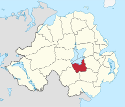
Craigavon (borough)
| Craigavon Borough | |
|---|---|
  |
|
 |
|
| Area | 378 km2 (146 sq mi) Ranked 19th of 26 |
| District HQ | Craigavon |
| Country | Northern Ireland |
| Sovereign state | United Kingdom |
| EU Parliament | Northern Ireland |
| Website | www |
Coordinates: 54°27′40″N 6°23′53″W / 54.461°N 6.398°W
Craigavon Borough Council was a local council in counties Armagh, Down and Antrim, in Northern Ireland. It merged with Armagh City and District Council and Banbridge District Council in May 2015 under local government reorganisation in Northern Ireland to become Armagh, Banbridge and Craigavon District Council.
The headquarters of the council was in Craigavon, on the shores of Lough Neagh, a new town built between Lurgan and Portadown. The council area included the large towns of Lurgan and Portadown, as well as smaller ones including Waringstown and Donaghcloney. The average council budget of £15.5 million provided a wide range of services to the 93,023 people living in the area.
The council area consisted of four electoral areas – Central, Loughside, Lurgan and Portadown – in which 26 councillors were elected every four years. The council held an annual meeting in June, at which a new Mayor and Deputy Mayor were elected. Parties elected in 2011, the last elections for the council, were Democratic Unionist Party (DUP) nine seats, Sinn Féin eight, Ulster Unionist Party (UUP) six, Social Democratic and Labour Party (SDLP) four, and Alliance Party of Northern Ireland one.
...
Wikipedia
