Crawley
| Borough of Crawley | ||
|---|---|---|
| Town & Borough | ||

Goff's Park House, Crawley, winter scene
|
||
|
||
| Motto: "I Grow and I Rejoice" | ||
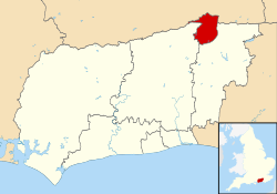
| Location of Crawley within West Sussex | ||
| Coordinates: 51°6′33″N 0°11′14″W / 51.10917°N 0.18722°WCoordinates: 51°6′33″N 0°11′14″W / 51.10917°N 0.18722°W | ||
| Sovereign state | United Kingdom | |
| Constituent country | England | |
| Region | South East England | |
| Ceremonial county | West Sussex | |
| Historic county |
Sussex (Town centre and outlying areas) Surrey (Gatwick Airport) |
|
| Admin HQ | Crawley, England | |
| Founded | 5th century | |
| Borough status | 1974 | |
| Government | ||
| • Type | Borough | |
| • Governing body | Crawley Borough Council | |
| • MP: | Henry Smith (C) | |
| • Mayor | Cllr Raj Sharma (L) | |
| • Control | ||
| Area | ||
| • Total | 17.36 sq mi (44.96 km2) | |
| Population (mid-2015 est.) | ||
| • Total | 110,900 (Ranked 211th) | |
| • Density | 5,750/sq mi (2,221/km2) | |
| • Ethnicity | 72.1% White British 6.8% Other White 5.2% Indian 4.3% Pakistani 2.6% Other Asian 2.0% British African Other groups less than 1% each |
|
| Time zone | Greenwich Mean Time (UTC+0) | |
| Postcode | RH6 and RH10–11 | |
| Area code(s) | 01293 | |
| ISO 3166-2 | GB-WSX (West Sussex) | |
| ONS code | 45UE (ONS) E07000226 (GSS) |
|
| OS grid reference | TQ268360 | |
| NUTS 3 | UKJ24 | |
| Website | www.crawley.gov.uk | |
| Labour Profile | ||
|---|---|---|
| Total employee jobs | 79,700 | |
| Full-time | 58,100 | 72.9% |
| Part-time | 21,600 | 27.1% |
| Manufacturing | 7,500 | 9.4% |
| Construction | 1,800 | 2.2% |
| Services | 70,100 | 87.9% |
| Distribution, hotels & restaurants | 19,600 | 24.6% |
| Transport & communications | 23,900 | 30.0% |
| Finance, IT, other business activities | 15,400 | 19.3% |
| Public admin, education & health | 9,600 | 12.1% |
| Other services | 1,600 | 2.0% |
| Tourism-related | 6,600 | 8.3% |
Crawley (![]() pronunciation ) is a town and borough in West Sussex, England. It is 28 miles (45 km) south of Charing Cross (London), 18 miles (29 km) north of Brighton and Hove, and 32 miles (51 km) north-east of the county town of Chichester. Crawley covers an area of 17.36 square miles (44.96 km2) and had a population of 106,597 at the time of the 2011 Census.
pronunciation ) is a town and borough in West Sussex, England. It is 28 miles (45 km) south of Charing Cross (London), 18 miles (29 km) north of Brighton and Hove, and 32 miles (51 km) north-east of the county town of Chichester. Crawley covers an area of 17.36 square miles (44.96 km2) and had a population of 106,597 at the time of the 2011 Census.
The area has been inhabited since the Stone Age, and was a centre of ironworking in Roman times. Crawley developed slowly as a market town from the 13th century, serving the surrounding villages in the Weald; its location on the main road from London to Brighton brought a passing trade, encouraging the development of coaching inns. It was connected to London by the railway in 1841.
Gatwick Airport, now one of Britain's busiest international airports, opened on the edge of the town in the 1940s, encouraging commercial and industrial growth. After the Second World War, the British Government planned to move large numbers of people and jobs out of London and into new towns around South East England. The New Towns Act 1946 designated Crawley as the site of one of these. A master plan was developed for the establishment of new residential, commercial, industrial and civic areas, and rapid development greatly increased the size and population of the town in a few decades.
...
Wikipedia


