Cronheim
| Cronheim | ||
|---|---|---|
| Stadtteil of Gunzenhausen | ||

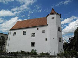
Cronheim Castle Historic Monument # D-5-77-136-149
|
||
|
||
| Coordinates: 49°05′48″N 10°39′50″E / 49.09667°N 10.66389°ECoordinates: 49°05′48″N 10°39′50″E / 49.09667°N 10.66389°E | ||
| Country | Germany | |
| State | Bavaria | |
| Admin. region | Mittelfranken | |
| District | Weißenburg-Gunzenhausen | |
| Town | Gunzenhausen | |
| Population ({{{Stand}}}) | ||
| • Total | 526 | |
| Time zone | CET/CEST (UTC+1/+2) | |
| Website | www.gunzenhausen.de | |
Cronheim is a village in the municipality of Gunzenhausen in the Weißenburg-Gunzenhausen district which forms part of the Bavarian Government district (in German: Regierungbezirk) of Mittelfranken. The hamlet of Filchenhard forms part of Cronheim.
Cronheim is situated in the Franconian Lake District (in German: Fränkisches Seenland), approximately seven kilometres west of Gunzenhausen. Bavarian state road 2218 lies north of the village.
The area around Cronheim was already populated in prehistoric and protohistoric time, proven by a circular earthwork in the north and two grave mounts in the south part of the village.
The human population that occupied the region during around 600 BC and 100 AC belonged to the Celtic Hallstatt culture. By the 6th century BC, the Hallstatt culture had expanded to include wide territories, falling into two zones, east and west, between them covering much of western and central Europe down to the Alps, and extending into northern Italy. In the neighbor village Kleinlellenfeld, north west from Cronheim, remainings of a Celtic settlement along with a Viereckschanze were found.
In the year 90 the Romans expelled the Celts, occupied the inhabited areas north of the Donau River and expanded into the area. The Celtic population wasn't banished from the region by the Romans but made tributary to them. To protect and getting control over the borders, the Roman started back in 138 under the roman Cesar Antoninus Pius to extend the roman boundary wall, Upper Germanic-Rhaetian Limes, and also included now the area north of Cronheim. Thanks to dendrochronological investigations of the wood used for the construction for the part of the Limes passing Cronheim, we now now that it was cut in 162, at the time when Marcus Aurelius was the Roman emperor, when this particular section of the Limes was built. In the second century two Roman military roads crossed at the location where Cronheim is now situated.
...
Wikipedia


