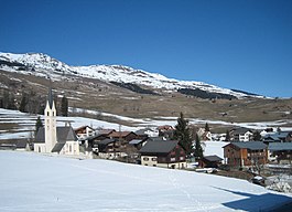
Degen, Switzerland
| Degen | ||
|---|---|---|
| Former municipality of Switzerland | ||
 |
||
|
||
| Coordinates: 46°42′N 9°10′E / 46.700°N 9.167°ECoordinates: 46°42′N 9°10′E / 46.700°N 9.167°E | ||
| Country | Switzerland | |
| Canton | Graubünden | |
| District | Surselva | |
| Area | ||
| • Total | 6.72 km2 (2.59 sq mi) | |
| Elevation | 1,122 m (3,681 ft) | |
| Population (Dec 2011) | ||
| • Total | 235 | |
| • Density | 35/km2 (91/sq mi) | |
| Postal code | 7145 | |
| SFOS number | 3594 | |
| Surrounded by | Vella, Vignogn, Suraua, Obersaxen. | |
| Website |
www SFSO statistics |
|
Degen (![]() [ˈdeɟən] , German: Igels) is a former municipality in the district of Surselva in the Swiss canton of Graubünden. Until 1983, it was officially known as Igels. The municipalities of Cumbel, Degen, Lumbrein, Morissen, Suraua, Vignogn, Vella, and Vrin merged on 1 January 2013 into the new municipality of Lumnezia.
[ˈdeɟən] , German: Igels) is a former municipality in the district of Surselva in the Swiss canton of Graubünden. Until 1983, it was officially known as Igels. The municipalities of Cumbel, Degen, Lumbrein, Morissen, Suraua, Vignogn, Vella, and Vrin merged on 1 January 2013 into the new municipality of Lumnezia.
Degen is first mentioned about 840 as Higenae/Egenae. Rumein was mentioned at about the same time as villa Ramnensis, and in 1325 Vattiz was mentioned as Vatigis.
Degen had an area, as of 2006[update], of 6.8 km2 (2.6 sq mi). Of this area, 78.1% is used for agricultural purposes, while 10.9% is forested. Of the rest of the land, 4% is settled (buildings or roads) and the remainder (7%) is non-productive (rivers, glaciers or mountains).
The former municipality is located in the Lugnez sub-district of the Surselva district. It is on a terrace about 200 m (660 ft) above the Glenner valley floor. It consists of the village of Degen and the hamlets of Rumein und Vattiz. Until 1983 Degen was known as Igels.
...
Wikipedia


