Desolation Peak (Washington)
| Desolation Peak | |
|---|---|

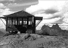
Desolation Peak Lookout with Mt. Hozomeen in the background
|
|
| Highest point | |
| Elevation | 6,102 ft (1,860 m) NGVD 29 |
| Prominence | 3,249 ft (990 m) |
| Coordinates | 48°54′40″N 121°00′58″W / 48.9112432°N 121.0162346°WCoordinates: 48°54′40″N 121°00′58″W / 48.9112432°N 121.0162346°W |
| Geography | |
|
|
|
| Parent range | North Cascades |
| Topo map | USGS Hozomeen Mountain |
| Climbing | |
| Easiest route | Trail hike |
Desolation Peak is in the North Cascade Mountains of Washington state, about 6.2 miles (10.0 km) south of the Canada–United States border and in the Ross Lake National Recreation Area. It was first climbed in 1926 by Lage Wernstedt, who named it for the destruction caused by a forest fire that swept the slopes bare that same year. At the summit stands a small, wooden, one room fire lookout belonging to the National Park Service. The lookout is 15 miles (24 km) from the nearest road and overlooks miles of forest and numerous other peaks.
Jack Kerouac spent 63 days during the summer of 1956 as a fire lookout on Desolation Peak. He wrote about his experiences in the books Lonesome Traveler, The Dharma Bums and Desolation Angels.
Desolation Peak Trail, is a steep hike to high meadows, great views and the fire lookout. It is a very popular hike but strenuous along the East Bank Trail. The trail is often hot and dry.
...
Wikipedia

