Dhalla
|
Dhalla ڈھـلہ |
|
|---|---|
| Town | |

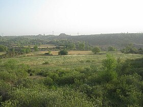
Dhalla View from Thapla
|
|
| Coordinates: 32°02′00″N 73°58′00″E / 32.0333°N 73.9667°E | |
| Country |
|
| Province | Punjab (Pakistan) |
| District | Rawalpindi |
| Tehsil | Rawalpindi Tehsil |
| Union council | Adiala |
| Government | |
| • Type | Union Council |
| Area | |
| • Total | 1.00 km2 (0.39 sq mi) |
| Elevation | 434 m (1,424 ft) |
| Population (2011) | |
| • Total | 2,700 |
| Time zone | PST (UTC+5) |
| Postal Code | 47311 |
| Calling code | 051 |
Dhalla (Urdu: ڈھـلہ) is a small town of Rawalpindi District in the Punjab province of Pakistan. It has 260 houses. It is located in Northern Punjab at 33°25'36N 72°57'25E with an altitude of 434 metres (1423 ft) and lies south of the district capital, Rawalpindi. The latest consolidation operation was held in 1986.
Before the independence of Pakistan in 1947, mostly population was Sikhs. Sikhs migrated back to India peacefully along with their brotherhood. Some people made caves in the hills of Dhalla as their shelter in the rain when they used to go with their herds. Dhalla till 2000 century had some remembrance of the Sikhs that Sikhs ever lived here. The caves were broken down for some construction purpose, so the last remembrance of Sikhs vanished.Before sikhs Government,Dhalla was a famous state of Pakhral Rajput and they ruled between Dhalla to chakwal
Dhalla is located on a hill on Adiala Road. It is 31.7 km (19.7 mi) away from the Islamabad International Airport and 19 km (12 mi) from Rawalpindi.
Dhalla has 2 dams in its surrounding areas, Jawa Dam and Khasala Dam in the village before Dhalla.The river Sawan is passing in front of the village.The bed of Sawan river is very fertile and full of greenry which have an outstanding look from the top of the village. The temperature in winter may decrease to 1 c and in June may rise up to 55 c. Mostly people are farmers and make their income from farming but the new generation know is moving towards industrial and government departments.
...
Wikipedia
