Doe River
| Doe River | |
| River | |
|
Doe River flowing from Roan Mountain to Elizabethton, Tennessee
|
|
| Country | United States |
|---|---|
| State | Tennessee |
| Region | Northeast Tennessee |
| District | Carter County |
| Municipality | Elizabethton |
| Tributaries | |
| - left | McCathern Spring |
| City | Hampton, Tennessee |
| Source | Roan Mountain (Roan Highlands) |
| - location | Roan Mountain, Tennessee, Northeast Tennessee, United States |
| Mouth | Watauga River |
| - location | Elizabethton, Tennessee, Northeast Tennessee, United States |
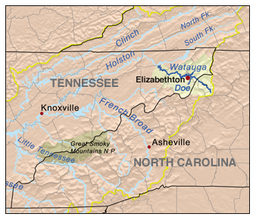
The Doe River is a tributary of the Watauga River in northeast Tennessee in the United States. The river forms in Carter County near the North Carolina line, just south of Roan Mountain State Park, and flows to Elizabethton.
The Doe River flows from the northern slopes of Roan Mountain, through Roan Mountain State Park and the center of Roan Mountain, Tennessee, then continues to flow west and is paralleled by U.S. Route 19E. The stream then flows to the east of Fork Mountain; while the Little Doe River flows by Fork Mountain to the west.
Pushing through a mountain gap just north of Hampton, Tennessee, the volume of the Doe River is increased by the waters flowing from McCathern Spring. Below the confluence of both the Doe River and the Little Doe River at Hampton, the Doe River travels roughly in a northern direction through the Valley Forge community, and is rejoined by U.S. Route 19E outside of Elizabethton.
Flowing parallel with U.S. Highway 19-E, the Doe River flows underneath two 19-E bridges at the East Side community before heading in a northwest angle toward the Elizabethton downtown business district. The Elizabethton Covered Bridge is located in downtown Elizabethton, the county seat of Carter County. Connecting 3rd Street and Hattie Avenue, the historic 1882 covered bridge spans the river is adjacent to a city park and county government areas. The bridge is open to pedestrians and bicyclists, but is closed to motor vehicle traffic.
The Doe River spills over a weir dam immediately downstream of the covered bridge, and flows under two 1928 concrete arch bridges in Elizabethton, prior to its confluence with the Watauga River. The first concrete arch bridge is the Elk Avenue Bridge in downtown Elizabethton; the second is locally known as the Broad Street Bridge and carries traffic on Tennessee State Route 67.
...
Wikipedia

