Domjur
|
Domjur ডোমজুড় |
|
|---|---|
| Census Town | |

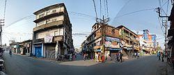
Amta road (SH-15) and Jagadishpur road junction
|
|
| Location in West Bengal, India | |
| Coordinates: 22°38′N 88°13′E / 22.64°N 88.22°ECoordinates: 22°38′N 88°13′E / 22.64°N 88.22°E | |
| Country |
|
| State | West Bengal |
| District | Howrah |
| Elevation | 11 m (36 ft) |
| Population (2011) | |
| • Total | 18,433 |
| Languages | |
| • Official | Bengali, English |
| Time zone | IST (UTC+5:30) |
| Lok Sabha constituency | Sreerampur |
| Vidhan Sabha constituency | Domjur, Jagatballavpur |
| Website | howrah |
Domjur is a census town in Domjur (community development block) in Sadar subdivision of Howrah district in the Indian state of West Bengal.
Domjur is located at 22°38′N 88°13′E / 22.64°N 88.22°E. It has an average elevation of 11 metres (36 feet).
As per 2011 Census of India Domjur had a total population of 18,433 of which 9,040 (49%) were males and 9,393 (51%) were females. Population below 6 years was 1,725. The total number of literates in Domjur was 14,396 (86.16% of the population over 6 years).
Domjur was part of Kolkata Urban Agglomeration in 2011 census.
As of 2001[update] India census, Domjur had a population of 16,822. Males constitute 50% of the population and females 50%. Domjur has an average literacy rate of 69%, higher than the national average of 59.5%: male literacy is 73% and, female literacy is 65%. In Domjur, 10% of the population is under 6 years of age.
Sastitala is the most biggest area of Domjur. Domjur has a large number of population belonging to Schedule Caste group. Hindus form about the two-thirds of the population, whereas Muslims make up about one-third.
Similar to the rest of Bengal, Durga Puja, Kali Puja, Eid al-Fitr and Christmas are the major festivals celebrated here.
...
Wikipedia

