Dungog Shire Council
|
Dungog Shire New South Wales |
|||||||||||||
|---|---|---|---|---|---|---|---|---|---|---|---|---|---|

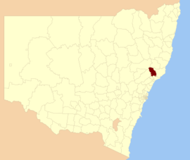
Location in New South Wales
|
|||||||||||||
| Coordinates | 32°24′S 151°45′E / 32.400°S 151.750°E | ||||||||||||
| Population | 9,195 (2015 est) | ||||||||||||
| • Density | 4.08/km2 (10.6/sq mi) | ||||||||||||
| Area | 2,251 km2 (869.1 sq mi) | ||||||||||||
| Time zone | AEST (UTC+10) | ||||||||||||
| • Summer (DST) | AEDT (UTC+11) | ||||||||||||
| Mayor | Harold Johnston (independent) | ||||||||||||
| Council seat | Dungog | ||||||||||||
| Region | Hunter | ||||||||||||
| State electorate(s) | Upper Hunter | ||||||||||||
| Federal Division(s) | Paterson | ||||||||||||
 |
|||||||||||||
| Website | Dungog Shire | ||||||||||||
|
|||||||||||||
Dungog Shire is a local government area in the Hunter region of New South Wales, Australia. The Shire is situated adjacent to the Barrington Tops and consists predominantly of very rugged to hilly country which becomes less rugged from north to south.
The mayor of the Dungog Shire Council is Clr. Harold Johnston, an independent politician.
The major population centres within the Shire are Dungog, Gresford, Paterson, Vacy, Martins Creek and Clarence Town. It also includes three main rivers, the Paterson River and Allyn River to the west and the Williams River to the east.
At the 2011 census, there were 8,318 people in the Dungog Shire local government area, of these 50.3 per cent were male and 49.7 per cent were female. Aboriginal and Torres Strait Islander people made up 3.2 per cent of the population, which was higher than the national and state averages of 2.5 per cent. The median age of people in the Dungog Shire was 44 years, significantly higher than the national median of 37 years. Children aged 0 – 14 years made up 18.8 per cent of the population and people aged 65 years and over made up 17.6 per cent of the population. Of people in the area aged 15 years and over, 54.7 per cent were married and 11.5 per cent were either divorced or separated.
...
Wikipedia
