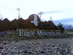
Eagle Mountain, Utah
| Eagle Mountain, Utah | |
|---|---|
| City | |

Eagle Mountain monument
|
|
 Location in Utah County and the state of Utah |
|
| Coordinates: 40°18′22″N 112°0′35″W / 40.30611°N 112.00972°WCoordinates: 40°18′22″N 112°0′35″W / 40.30611°N 112.00972°W | |
| Country | United States |
| State | Utah |
| County | Utah |
| Incorporated | December 3, 1996 |
| Became a city | May 31, 2001 |
| Government | |
| • Type | Six Member Council |
| • Mayor | Christopher Pengra |
| • Councilmembers | Adam Bradley, Colby Curtis, Stephanie Gricius, Ben Reaves, Tom Westmoreland |
| Area | |
| • Total | 41.7 sq mi (108.0 km2) |
| • Land | 41.7 sq mi (108.0 km2) |
| • Water | 0.0 sq mi (0.0 km2) |
| Elevation | 4,882 ft (1,488 m) |
| Population (2012) | |
| • Total | 23,212 |
| • Density | 560/sq mi (210/km2) |
| Time zone | Mountain (MST) (UTC-7) |
| • Summer (DST) | MDT (UTC-6) |
| ZIP code | 84005 |
| Area code(s) | 385, 801 |
| FIPS code | 49-20810 |
| GNIS feature ID | 1759211 |
| Website | www.emcity.org |
Eagle Mountain is a city in Utah County, Utah, United States. It is part of the Provo–Orem, Utah Metropolitan Statistical Area. The city is located to the west as well as north of the Lake Mountains, which are west of Utah Lake. It was incorporated December 3, 1996 and has been rapidly growing ever since. The population was 21,415 at the 2010 census. Although Eagle Mountain was a town in 2000, it has since been classified as a fourth-class city by state law. In its short history, the city has quickly become known for its rapid growth.
Eagle Mountain is located at the western and northern bases of the Lake Mountains in the flat Cedar Valley northeast of the city of Cedar Fort. According to the United States Census Bureau, the city has a total area of 41.7 square miles (108.0 km2).
SR-73 and Eagle Mountain Boulevard provide access to the city from Utah Valley and Salt Lake Valley, although the city center sits at least 15 miles (24 km) from the two valleys' main transportation corridor along Interstate 15. The Utah Department of Transportation is in the process of building a western freeway for the Salt Lake Valley (the Mountain View Corridor), which will connect to SR-73 only a few miles from the city.
The area is home to a number of natural landmarks, including a site along the original Pony Express trail and 1,800-year-old rock art petroglyphs carved by ancient Fremont Indians.
In 2011 Eagle Mountain extended further west with the annexation of the White Hills neighborhood, which had about 400 residents, as well as area that is part of the Pole Canyon development plan. The land outside of white hills was Almost 2,900 acres.
As of the census of 2010, there were 21,415 people, 5,111 households, and 4,741 families residing in the town. The population density was 513.6 inhabitants per square mile (20.0/km²). There were 5,546 housing units at an average density of 133 per square mile. The racial makeup of the town was 91.9% White, 0.6% African American, 0.5% American Indian and Alaskan Native, 0.6% Asian, 0.6% Pacific Islander, 2.7% from other races, and 3.1% from two or more races. Hispanic or Latino of any race were 8.6% of the population.
...
Wikipedia
