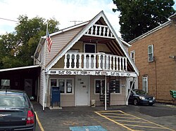
East Otto, New York
| East Otto, New York | |
|---|---|
| Town | |

East Otto Post Office, August 2010
|
|
| Location within the state of New York | |
| Coordinates: 42°23′19″N 78°44′28″W / 42.38861°N 78.74111°W | |
| Country | United States |
| State | New York |
| County | Cattaraugus |
| Government | |
| • Type | Town Council |
| • Town Supervisor | James A. Beach (R) |
| • Town Council |
Members' List
|
| Area | |
| • Total | 40.4 sq mi (104.6 km2) |
| • Land | 40.1 sq mi (103.8 km2) |
| • Water | 0.3 sq mi (0.8 km2) |
| Elevation | 1,522 ft (464 m) |
| Population (2010) | |
| • Total | 1,062 |
| • Density | 26/sq mi (10.2/km2) |
| Time zone | Eastern (EST) (UTC-5) |
| • Summer (DST) | EDT (UTC-4) |
| ZIP code | 14729 |
| Area code(s) | 716 |
| FIPS code | 36-22678 |
| GNIS feature ID | 0978921 |
| Website | eastottony |
East Otto is a town in Cattaraugus County, New York, United States. The population was 1,062 at the 2010 census. The town, along with neighboring Otto, is named after an agent of the Holland Land Company, Jacob Otto. The town of East Otto is on the northern border of the county.
The town of East Otto was founded in 1854. As its name implies, the town was formed from the eastern half of the town of Otto, which at the time covered most of the north-central portion of the county. East Otto was one of the last towns to be formed in Cattaraugus County.
The East Otto Union School, which currently serves as the town hall, is listed on the National Register of Historic Places.
According to the United States Census Bureau, the town has a total area of 40.4 square miles (104.6 km2), of which 40.1 square miles (103.8 km2) is land and 0.31 square miles (0.8 km2), or 0.81%, is water.
The north town line is marked by Cattaraugus Creek and is the border of Erie County.
Cattaraugus County Route 12 is the primary highway through the area, heading westward toward Otto and northward to U.S. Route 219 in Ashford. Cattaraugus County Route 14 (Reed Hill Road) heads southward toward Little Valley, while Cattaraugus County Route 75 (Plato Road) travels east/southeast to US 219 along a more southerly route. Routes 12, 14, and 75 converge at the hamlet of East Otto.
As of the census of 2000, there were 1,105 people, 412 households, and 285 families residing in the town. The population density was 26.8 people per square mile (10.4/km²). There were 545 housing units at an average density of 13.2 per square mile (5.1/km²). The racial makeup of the town was 98.37% White, 0.45% African American, 0.09% Native American, 0.27% Asian, 0.36% from other races, and 0.45% from two or more races. Hispanic or Latino of any race were 0.72% of the population.
...
Wikipedia

