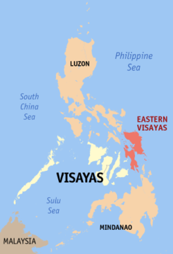
Eastern Visayas
|
Eastern Visayas Region VIII |
|
|---|---|
| Region | |
![Clockwise from top: San Juanico BridgePintados FestivalBiliran shirtSts. Peter and Paul Cathedral in Calbayog CityBlanca Aurora falls in San JorgeMesa de PalapagThe Obelisk,[1]MacArthur park in Palo, Leyte](http://upload.wikimedia.org/wikipedia/commons/thumb/1/17/Eastern_Visayas.png/250px-Eastern_Visayas.png)
Clockwise from top:
|
|
 Location in the Philippines |
|
| Coordinates: 11°14′N 125°03′E / 11.24°N 125.05°ECoordinates: 11°14′N 125°03′E / 11.24°N 125.05°E | |
| Country | Philippines |
| Island group | Visayas |
| Regional center | Tacloban |
| Area | |
| • Total | 23,251.10 km2 (8,977.30 sq mi) |
| Population (2015 census) | |
| • Total | 4,440,150 |
| • Density | 190/km2 (490/sq mi) |
| Time zone | PST (UTC+8) |
| ISO 3166 code | PH-08 |
| Provinces | |
| Cities | |
| Municipalities | 136 |
| Barangays | 4,390 |
| Cong. districts | 12 |
| Languages |
|
Eastern Visayas (Filipino: Silangang Kabisayaan, Waray: Sinirangan Kabisay-an; Cebuano: Sidlakang Kabisay-an) is an administrative region in the Philippines, designated as Region VIII. It consists of three main islands, Samar, Leyte and Biliran. The region has six provinces, one independent city and one highly urbanized city namely, Biliran, Leyte, Northern Samar, Samar, Eastern Samar, Southern Leyte, Ormoc and Tacloban. The highly urbanized city of Tacloban is the Eastern Visayas Regional Center (EVRC). These provinces and cities occupy the easternmost islands of the Visayas group of islands.
Eastern Visayas faces the Philippine Sea to the east. The region is known for its famous landmark, the San Juanico Bridge, dubbed as the "Most Beautifully Designed and Longest Bridge in the Philippines". As of 2015, the region has a population of 4,440,150 people.
Eastern Visayas lies on the east central section of the Philippine archipelago. It consists of three main islands, Leyte, Samar, and Biliran which form the easternmost coast of the archipelago. It is bounded on the east and north by the Philippine Sea with the San Bernardino Strait separating Samar island from southeastern Luzon; on the west by the Camotes and Visayan seas, and on the south by the Bohol Sea with the Surigao Strait separating Leyte island from northwestern Mindanao. It has a total land area of 2,156,285 hectares (5,328,300 acres) or 7.2% of the country’s total land area. 52% of its total land area are classified as forestland and 48% as alienable and disposable land.
...
Wikipedia
