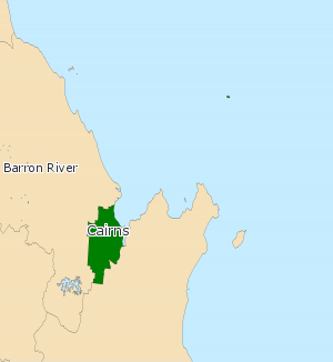
Electoral district of Cairns
|
Cairns Queensland—Legislative Assembly |
|
|---|---|

Cairns (2008—)
|
|
| State | Queensland |
| MP | Rob Pyne |
| Party | Independent |
| Namesake | Cairns |
| Electors | 36,290 (2015) |
| Area | 49 km2 (18.9 sq mi) |
| Coordinates | 16°56′S 145°45′E / 16.933°S 145.750°ECoordinates: 16°56′S 145°45′E / 16.933°S 145.750°E |
Cairns is an electoral district in the Legislative Assembly of Queensland in the state of Queensland, Australia.
The division encompasses the central business district and inner-suburbs of Cairns, in Far North Queensland. Major locations include Bungalow, Manoora, Kanimbla, Earlville and Woree.
Created in 1888, Cairns has historically tended to be a safe Labor seat with a blue-collar economy based on sugar, mining and railways. However, in recent decades such industry has been surpassed in importance by tourism and service industries for wealthier retirees and has grown increasingly marginal.
...
Wikipedia
