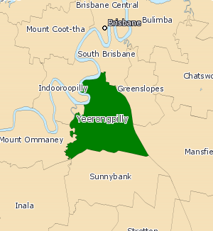
Electoral district of Yeerongpilly
|
Yeerongpilly Queensland—Legislative Assembly |
|
|---|---|

Yeerongpilly (2008—)
|
|
| State | Queensland |
| Dates current | 2001–present |
| MP | Mark Bailey |
| Party | Labor |
| Namesake | Yeerongpilly |
| Electors | 33,724 (2015) |
| Area | 36 km2 (13.9 sq mi) |
| Coordinates | 27°32′S 153°2′E / 27.533°S 153.033°ECoordinates: 27°32′S 153°2′E / 27.533°S 153.033°E |
Yeerongpilly is a Legislative Assembly electorate the state of Queensland. Named for the suburb with the same name, the electorate was renamed before the 2001 elections, from the previous name of Yeronga.
Yeerongpilly is bordered by the Brisbane River and Oxley Creek to the north and west, while the electoral districts of Greenslopes, Mansfield, South Brisbane and Sunnybank border it on the east and south. The division includes suburbs in Brisbane's inner south, including Annerley, Fairfield, Moorooka, Nathan, Rocklea, Salisbury, Tarragindi, Yeronga, and Yeerongpilly. Many landmarks, including the Nathan campus of Griffith University and the Queensland Sport and Athletics Centre fall in the electorate.
...
Wikipedia
