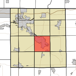
Elkhart Township, Elkhart County, Indiana
| Elkhart Township | |
|---|---|
| Township | |
 Location of Elkhart Township in Elkhart County |
|
| Coordinates: 41°33′59″N 85°49′41″W / 41.56639°N 85.82806°WCoordinates: 41°33′59″N 85°49′41″W / 41.56639°N 85.82806°W | |
| Country | United States |
| State | Indiana |
| County | Elkhart |
| Government | |
| • Type | Indiana township |
| Area | |
| • Total | 35.69 sq mi (92.4 km2) |
| • Land | 35.04 sq mi (90.8 km2) |
| • Water | 0.65 sq mi (1.7 km2) |
| Elevation | 804 ft (245 m) |
| Population (2010) | |
| • Total | 36,487 |
| • Density | 1,041.2/sq mi (402.0/km2) |
| FIPS code | 18-20746 |
| GNIS feature ID | 453275 |
Elkhart Township is one of sixteen townships in Elkhart County, Indiana. As of the 2010 census, its population was 36,487.
The Dierdorff Farmstead was listed on the National Register of Historic Places in 2011.
According to the 2010 census, the township has a total area of 35.69 square miles (92.4 km2), of which 35.04 square miles (90.8 km2) (or 98.18%) is land and 0.65 square miles (1.7 km2) (or 1.82%) is water.
The township contains seven cemeteries: Cripe, Elkhart Prairie, Hess, Oak Ridge, Sparklin, Studebaker and Violett.
...
Wikipedia
