Elwood, Utah
| Elwood, Utah | |
|---|---|
| Town | |

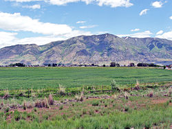
Town of Elwood, with Mendon Peak in background
|
|
 Location in Box Elder County and the state of Utah |
|
 Location of Utah in the United States |
|
| Coordinates: 41°40′27″N 112°8′29″W / 41.67417°N 112.14139°WCoordinates: 41°40′27″N 112°8′29″W / 41.67417°N 112.14139°W | |
| Country | United States |
| State | Utah |
| County | Box Elder |
| Settled | 1868 |
| Incorporated | 1933 |
| Government | |
| • Mayor | Keenan Nelson |
| Area | |
| • Total | 7.83 sq mi (20.27 km2) |
| • Land | 7.81 sq mi (20.24 km2) |
| • Water | 0.02 sq mi (0.04 km2) |
| Elevation | 4,298 ft (1,310 m) |
| Population (2012 est.) | |
| • Total | 1,029 |
| • Density | 132/sq mi (50.8/km2) |
| Time zone | Mountain (MST) (UTC-7) |
| • Summer (DST) | MDT (UTC-6) |
| ZIP code | 84337 |
| Area code(s) | 435 |
| FIPS code | 49-22760 |
| GNIS feature ID | 1427809 |
| Website | www |
Elwood is a town in Box Elder County, Utah, United States. The population was 1,034 at the 2010 census.
Elwood is located in eastern Box Elder County in the Bear River Valley. The Bear River forms part of the eastern border of the town, and the Malad River forms part of the western border. The town of Deweyville and the city of Honeyville are to the east, and the city of Tremonton is to the northwest.
Interstate Highways 15 and 84 run through the town, with access from Exit 376 (Utah State Route 13, the main local road through the town).
According to the United States Census Bureau, the town has a total area of 7.8 square miles (20.3 km2), of which 0.02 square miles (0.04 km2), or 0.17%, is water.
As of the census of 2000, there were 678 people, 194 households, and 170 families residing in the town. The population density was 88.5 people per square mile (34.2/km²). There were 198 housing units at an average density of 25.8 per square mile (10.0/km²). The racial makeup of the town was 93.95% White, 0.44% Native American, 1.33% Asian, 3.10% from other races, and 1.18% from two or more races. Hispanic or Latino of any race were 4.28% of the population.
...
Wikipedia
