Esbon
| Esbon, Kansas | |
|---|---|
| City | |
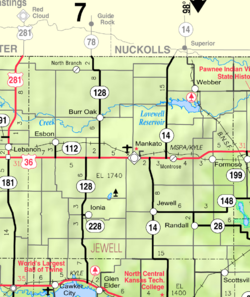
 Location within Jewell County and Kansas |
|
 KDOT map of Jewell County (legend) |
|
| Coordinates: 39°49′22″N 98°26′2″W / 39.82278°N 98.43389°WCoordinates: 39°49′22″N 98°26′2″W / 39.82278°N 98.43389°W | |
| Country | United States |
| State | Kansas |
| County | Jewell |
| Area | |
| • Total | 0.31 sq mi (0.80 km2) |
| • Land | 0.31 sq mi (0.80 km2) |
| • Water | 0 sq mi (0 km2) |
| Elevation | 1,844 ft (562 m) |
| Population (2010) | |
| • Total | 99 |
| • Estimate (2015) | 96 |
| • Density | 320/sq mi (120/km2) |
| Time zone | Central (CST) (UTC-6) |
| • Summer (DST) | CDT (UTC-5) |
| ZIP code | 66941 |
| Area code | 785 |
| FIPS code | 20-21600 |
| GNIS feature ID | 0471981 |
| Website | City Website |
Esbon is a city in Jewell County, Kansas, United States. As of the 2010 census, the city population was 99.
Esbon was laid out in 1873. It was incorporated as a city in 1904.
The first post office in Esbon was established in January 1874.
Esbon was a shipping point on the Chicago, Rock Island and Pacific Railroad.
Esbon is located at 39°49′22″N 98°26′2″W / 39.82278°N 98.43389°W (39.822656, -98.433762). According to the United States Census Bureau, the city has a total area of 0.31 square miles (0.80 km2), all of it land.
The town lies 2.5 miles north of U.S. Route 36, and 13 miles west of Mankato, the county seat of Jewell County.
The town has a Roman Catholic church, Sacred Heart, and also has a United Methodist Church.
As of the census of 2010, there were 99 people, 52 households, and 24 families residing in the city. The population density was 319.4 inhabitants per square mile (123.3/km2). There were 84 housing units at an average density of 271.0 per square mile (104.6/km2). The racial makeup of the city was 91.9% White, 1.0% African American, 3.0% Native American, and 4.0% from two or more races. Hispanic or Latino of any race were 1.0% of the population.
...
Wikipedia
