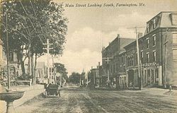
Farmington (CDP), Maine
| Farmington, Maine | |
|---|---|
| Census-designated place | |

Main Street
|
|
| Location within the state of Maine | |
| Coordinates: 44°40′12″N 70°8′47″W / 44.67000°N 70.14639°WCoordinates: 44°40′12″N 70°8′47″W / 44.67000°N 70.14639°W | |
| Country | United States |
| State | Maine |
| County | Franklin |
| Town | Farmington |
| Area | |
| • Total | 4.05 sq mi (10.48 km2) |
| • Land | 4.03 sq mi (10.45 km2) |
| • Water | 0.01 sq mi (0.03 km2) |
| Elevation | 413 ft (126 m) |
| Population (2010) | |
| • Total | 4,288 |
| • Density | 1,063/sq mi (410.3/km2) |
| Time zone | Eastern (EST) (UTC-5) |
| • Summer (DST) | EDT (UTC-4) |
| ZIP code | 04938 |
| Area code(s) | 207 |
| FIPS code | 23-24740 |
| GNIS feature ID | 0566054 |
Farmington is a census-designated place (CDP) comprising the center of the town of Farmington, which is the county seat of Franklin County in Maine, United States. The population of the CDP was 4,288 at the 2010 census, out of 7,760 people in the town as a whole. The University of Maine at Farmington is located within the CDP.
The Farmington CDP is located at the geographic center of the town of Farmington, at 44°40′11″N 70°8′46″W / 44.66972°N 70.14611°W (44.669885, -70.146322).U.S. Route 2 passes through the southern part of the CDP, leading east 27 miles (43 km) to Skowhegan and west 30 miles (48 km) to Rumford. Maine State Route 4 runs through the center of the CDP, leading northwest 40 miles (64 km) to Rangeley and south 46 miles (74 km) to Lewiston. Maine State Route 27 also runs through the center of town, following ME 4 out of town to the north and US 2 out of town to the southeast; ME 27 leads north 72 miles (116 km) to the Canada–US border at Coburn Gore and southeast 37 miles (60 km) to Augusta, the state capital.
...
Wikipedia

