Ferfer
|
Fērfēr Feerfeer |
|
|---|---|
| Location in Ethiopia | |
| Coordinates: 05°05′N 45°05′E / 5.083°N 45.083°ECoordinates: 05°05′N 45°05′E / 5.083°N 45.083°E | |
| Country | Ethiopia |
| Region | Somali Region |
| Elevation | 177 m (581 ft) |
| Population (2005) | |
| • Total | 4,411 (est) |
| Time zone | EAT (UTC+3) |
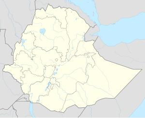
Fer-fer is a town in the Ethiopian Somali Regional State,Close to the border between Ethiopian and Somalia (Hiiraan region), this town has a latitude and longitude of 05°05′N 45°05′E / 5.083°N 45.083°E with an elevation of 177 meters above sea level.
During the first three months of 1964, heavy fighting took place between Ethiopia and Somalia at several border points in the Ogaden, one of which was Ferfer. Ferfer was among the locations within Ethiopia that were still under Somali control after Somalia's defeat in the Ogaden War of 1977/78.
The Ethiopian army maintains an important base in Ferfer. In June 2008, the border town was briefly seized by the Somali al-Shabaab.
Based on figures from the Central Statistical Agency in 2005, Ferfer has an estimated total population of 4,411 of whom 2,418 are men and 1,993 are women. The 1997 census reported this town had a total population of 2,956 of whom 1,597 were men and 1,359 women. All of the inhabitants of this town belonged to the Somali people. It is the largest settlement in Ferfer woreda.
...
Wikipedia

