Ferntree Gully
|
Ferntree Gully Melbourne, Victoria |
|||||||||||||
|---|---|---|---|---|---|---|---|---|---|---|---|---|---|

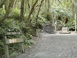
The "1000 steps" Kokoda Track Memorial Walk in The Dandenong Ranges National Park
|
|||||||||||||
| Coordinates | 37°53′10″S 145°16′56″E / 37.8862°S 145.2821°ECoordinates: 37°53′10″S 145°16′56″E / 37.8862°S 145.2821°E | ||||||||||||
| Population | 24,724 (2006) | ||||||||||||
| • Density | 1,555/km2 (4,027/sq mi) | ||||||||||||
| Established | 1880s | ||||||||||||
| Postcode(s) | 3156 | ||||||||||||
| Elevation | 150 m (492 ft) | ||||||||||||
| Area | 15.9 km2 (6.1 sq mi) | ||||||||||||
| Location | |||||||||||||
| LGA(s) | |||||||||||||
| State electorate(s) | |||||||||||||
| Federal Division(s) | |||||||||||||
|
|||||||||||||
Ferntree Gully is a suburb in Melbourne, Victoria, Australia, at the foothills of the Dandenong Ranges, 32 km east of Melbourne's central business district. It is in the local government area of the City of Knox. At the 2011 Census, Ferntree Gully had a population of 25,585: 49.5% of this male and 50.5% female. The median/average age of a person was 38 years, one year above the Australian average. 75% of people living in Ferntree Gully were born in Australia. 48.5% of people are married. The suburb is on the Belgrave train line and it takes between 42 minutes (stopping all stations and then express service from Box Hill) to 60 minutes (all stations service) to Flinders Street, CBD.
The William Angliss Public Hospital and Emergency Centre is located east in Upper Ferntree Gully, approximately 2 kilometres just off Burwood Highway.
Ferntree Gully, The Basin, Boronia and Upper Ferntree Gully are the only Dandenong Ranges towns or suburbs in the City of Knox (although some parts of Upper Ferntree Gully are within the Shire of Yarra Ranges). The City of Knox is one of the few cities not broken-up during the Kennett government review of councils and had its area expanded to include parts of Upper Ferntree Gully that were previously in the Shire of Sherbrooke (now part of the Yarra Ranges Shire).
Ferntree Gully and Belgrave are sister suburbs and are very closely linked in many ways. Ferntree Gully is younger than Belgrave (Belgrave being established in 1851 and Ferntree Gully in 1880).
Ferntree Gully has many Eucalyptus trees (gum trees) and lies at the foothills of the Dandenong Ranges. Its boundaries meet Upper Ferntree Gully, a separate but similarly named suburb with the same postcode, Boronia to the North, Scoresby to the West and Lysterfield to the South. The eastern boundary coincides with the Ferntree Gully National Park which is a National Park administered by the Federal Government. Ferntree Gully is in a high fire risk area in the vicinity of the Ferntree Gully National Park, however the majority of the suburb is considered low risk.
...
Wikipedia

