FishHawk, Florida
|
FishHawk, Florida Fish Hawk |
|
|---|---|
| Census-designated place | |

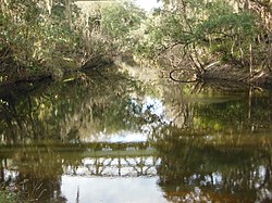
The Alafia River in FishHawk
|
|
 Location in Hillsborough County and the state of Florida |
|
| Coordinates: 27°51′10″N 82°12′31″W / 27.85278°N 82.20861°WCoordinates: 27°51′10″N 82°12′31″W / 27.85278°N 82.20861°W | |
| Country | United States |
| State | Florida |
| County | Hillsborough |
| Area | |
| • Total | 16.4 sq mi (42.4 km2) |
| • Land | 16.2 sq mi (42.0 km2) |
| • Water | 0.2 sq mi (0.4 km2) |
| Elevation | 62 ft (19 m) |
| Population (2010) | |
| • Total | 14,087 |
| • Density | 869/sq mi (335.5/km2) |
| Time zone | Eastern (EST) (UTC-5) |
| • Summer (DST) | EDT (UTC-4) |
| ZIP Code | 33547 (Lithia) |
| Area code(s) | 813 |
| FIPS code | 12-22387 |
| GNIS feature ID | 2402482 |
FishHawk is an unincorporated area and census-designated place (CDP) in Hillsborough County, Florida, United States. It includes the community of Lithia. As of the 2010 census, the CDP had a population of 14,087, up from 1,991 at the 2000 census. The place name is derived from Fishhawk Creek, a tributary of the Alafia River that joins the Alafia just west of Lithia Springs.
FishHawk is located in east-central Hillsborough County at 27°51′10″N 82°12′31″W / 27.85278°N 82.20861°W (27.852803, -82.208592). It is bordered to the north by the Alafia River, which separates it from Valrico to the north and Bloomingdale to the northwest. Riverview borders FishHawk to the southwest. FishHawk is 20 miles (32 km) southeast of downtown Tampa.
The older community of Lithia is in the eastern part of the CDP.
According to the United States Census Bureau, the CDP has a total area of 16.4 square miles (42.4 km2), with 16.2 square miles (42.0 km2) of land and 0.2 square miles (0.4 km2), or 1.03%, of water.
FishHawk is a community comprising several subdivisions, or "mini communities", located west of Lithia.
...
Wikipedia
