Florenville
| Florenville | ||
|---|---|---|
| Municipality | ||

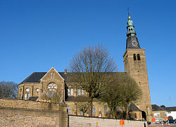
Church of Our Lady of the Assumption
|
||
|
||
| Location in Belgium | ||
| Coordinates: 49°41.9′N 5°18.6′E / 49.6983°N 5.3100°ECoordinates: 49°41.9′N 5°18.6′E / 49.6983°N 5.3100°E | ||
| Country | Belgium | |
| Community | French Community | |
| Region | Wallonia | |
| Province | Luxembourg | |
| Arrondissement | Virton | |
| Government | ||
| • Mayor | Sylvie THÉODORE | |
| • Governing party/ies | cdH, PS | |
| Area | ||
| • Total | 146.91 km2 (56.72 sq mi) | |
| Population (1 January 2016) | ||
| • Total | 5,632 | |
| • Density | 38/km2 (99/sq mi) | |
| Postal codes | 6820-6824 | |
| Area codes | 061 | |
| Website | www.florenville.be | |
Florenville is a Walloon municipality located in the Belgian province of Luxembourg. On 1 January 2016 the municipality had 5,639 inhabitants. The total area is 146.91 km², giving a population density of 38.38 inhabitants per km².
It is located on the Semois River, facing the French border.
The municipality consists of the following sub-municipalities: Florenville proper, Chassepierre, Fontenoille, Lacuisine, Muno, Sainte-Cécile, and Villers-devant-Orval. Other population centers include: Azy, Conques, Laiche, Martué, Lambermont, Le Menil, and Watrinsart.
Orval Abbey is located in Villers-devant-Orval.
...
Wikipedia


