Fondachelli-Fantina
| Fondachelli-Fantina | |
|---|---|
| Comune | |
| Comune di Fondachelli-Fantina | |

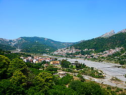
sight of Fondachelli Fantina under the Rocca di Salvatesta
|
|
| Location of Fondachelli-Fantina in Italy | |
| Coordinates: 37°59′N 15°10′E / 37.983°N 15.167°ECoordinates: 37°59′N 15°10′E / 37.983°N 15.167°E | |
| Country | Italy |
| Region | Sicily |
| Province / Metropolitan city | Messina (ME) |
| Government | |
| • Mayor | Francesco Pettinato |
| Area | |
| • Total | 41.0 km2 (15.8 sq mi) |
| Elevation | 604 m (1,982 ft) |
| Population (30 November 2011) | |
| • Total | 1,117 |
| • Density | 27/km2 (71/sq mi) |
| Demonym(s) | Fondachellesi or fantinesi |
| Time zone | CET (UTC+1) |
| • Summer (DST) | CEST (UTC+2) |
| Postal code | 98050 |
| Dialing code | 0941 |
| Website | Official website |
Fondachelli-Fantina is a comune (municipality) in the Metropolitan City of Messina, Sicily, southern Italy. Situated between Novara and Francavilla di Sicilia, in the southern Peloritani mountains, it rises on an inland area and is 604 metres (1,982 ft) above sea level, around the bed of the Patrì river, the mythical Longanus river of the ancient times that arises in the valley. The community also borders the municipalities of Antillo and Rodì Milici. The main mountains of his valley are Montagna Grande, Rocca Salvatesta, Montagna di Vernà, Pizzo Russa, Pizzo Vento and Rocche di Durante. It is 81 km from Catania, 87 kilometres (54 mi) from Messina, 129 kilometres (80 mi) from Syracuse, and 235 kilometres (146 mi) from Palermo.
Developed from a number of rural hamlets in the territory of Novara di Sicilia, the collective community attained autonomous status in 1950 and called itself Fondachelli-Fantina, a name derived from Fondaci (Arabic funduq : "stores" or "warehouses") and Fantinia (Latin infans: "child"). It is historically important as one of the last Sicilian municipalities where Gallo-Sicilian survives as a spoken dialect making the town a linguistic island.
...
Wikipedia

