Frenchville, Maine
| Frenchville, Maine | |
|---|---|
| Town | |
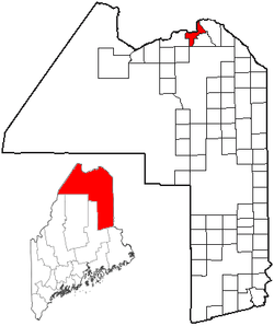
 Location of Frenchville, Maine |
|
| Coordinates: 47°17′7″N 68°23′14″W / 47.28528°N 68.38722°WCoordinates: 47°17′7″N 68°23′14″W / 47.28528°N 68.38722°W | |
| Country | United States |
| State | Maine |
| County | Aroostook |
| Area | |
| • Total | 29.17 sq mi (75.55 km2) |
| • Land | 28.71 sq mi (74.36 km2) |
| • Water | 0.46 sq mi (1.19 km2) |
| Elevation | 633 ft (193 m) |
| Population (2010) | |
| • Total | 1,087 |
| • Estimate (2012) | 1,073 |
| • Density | 37.9/sq mi (14.6/km2) |
| Time zone | Eastern (EST) (UTC−5) |
| • Summer (DST) | EDT (UTC−4) |
| ZIP code | 04745 |
| Area code(s) | 207 |
| FIPS code | 23-26735 |
| GNIS feature ID | 0582483 |
Frenchville is a town in Aroostook County, Maine, United States. The population was 1,087 at the 2010 census: 80 percent are habitual speakers of French, aided by its proximity to French-speaking Quebec and New Brunswick in Canada.
The town is home to the general aviation airport Northern Aroostook Regional Airport, Frenchville Railroad Station and Water Tank, and Corriveau Mill.
According to the United States Census Bureau, the town has a total area of 29.17 square miles (75.55 km2), of which 28.71 square miles (74.36 km2) is land and 0.46 square miles (1.19 km2) is water. The town lies on the south bank of the Saint John River, which forms the international boundary between Maine and New Brunswick, Canada.
As of the census of 2010, there were 1,087 people, 459 households, and 346 families residing in the town. The population density was 37.9 inhabitants per square mile (14.6/km2). There were 514 housing units at an average density of 17.9 per square mile (6.9/km2). The racial makeup of the town was 98.4% White, 0.2% Native American, 0.2% from other races, and 1.2% from two or more races. Hispanic or Latino of any race were 0.8% of the population.
...
Wikipedia
