Fruitvale, Texas
| Fruitvale, Texas | |
|---|---|
| City | |
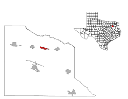
 Location of Fruitvale, Texas |
|
| Coordinates: 32°40′59″N 95°47′59″W / 32.68306°N 95.79972°WCoordinates: 32°40′59″N 95°47′59″W / 32.68306°N 95.79972°W | |
| Country | United States |
| State | Texas |
| County | Van Zandt |
| Area | |
| • Total | 1.9 sq mi (5.0 km2) |
| • Land | 1.9 sq mi (5.0 km2) |
| • Water | 0.0 sq mi (0.0 km2) |
| Elevation | 466 ft (142 m) |
| Population (2010) | |
| • Total | 408 |
| • Density | 210/sq mi (82/km2) |
| Time zone | Central (CST) (UTC-6) |
| • Summer (DST) | CDT (UTC-5) |
| ZIP code | 75127 |
| Area code(s) | 903 |
| FIPS code | 48-27804 |
| GNIS feature ID | 1336284 |
Fruitvale is a small city in Van Zandt County, Texas, United States. The population was 408 at the 2010 census, and 409 as of 2013. The town draws its name from its location. Missouri Pacific Railroad in the center of the historic fruit-growing district of the Sabine River valley in northeastern Van Zandt County. Its name was originally Bolen Switch, but it was changed around 1901 after a petition of local fruit growers, and a post office was established in 1903.
Fruitvale is located at 32°40′59″N 95°47′59″W / 32.68306°N 95.79972°W (32.682930, -95.799609). It lies along U.S. Highway 80 between Edgewood and Grand Saline.
According to the United States Census Bureau, the city has a total area of 1.9 square miles (4.9 km²), all of it land.
As of the census of 2000, there were 418 people, 157 households, and 116 families residing in the city. The population density was 218.4 people per square mile (84.5/km²). There were 172 housing units at an average density of 89.9 per square mile (34.8/km²). The racial makeup of the city was 92.82% White, 0.96% African American, 0.96% Native American, 0.24% Asian, 2.87% from other races, and 2.15% from two or more races. Hispanic or Latino of any race were 3.59% of the population.
...
Wikipedia
