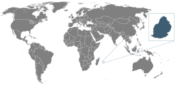
Geography of Mauritius
|
Native name: Maurice Nickname: The Star and Key of the Indian Ocean |
|
|---|---|

Location of Mauritius
|
|
| Geography | |
| Location | Indian Ocean |
| Coordinates | 20°17′S 57°33′E / 20.283°S 57.550°E |
| Archipelago | Mascarene Islands |
| Area | 2,011 km2 (776 sq mi) |
| Highest elevation | 828 m (2,717 ft) |
| Highest point | Piton de la Petite Rivière Noire |
| Administration | |
| Largest settlement | Port Louis (pop. 147,688) |
| Demographics | |
| Population | 1,264,866 (2007) |
| Pop. density | 616 /km2 (1,595 /sq mi) |
| Ethnic groups | Indo-Mauritian 68%, Mauritian Creole people 27%, Sino-Mauritian 3%, Franco-Mauritian 2% |
Mauritius is an island off Africa's southeast coast located in the Indian Ocean, east of Madagascar.
The local climate is tropical, modified by southeast trade winds; there is a warm, dry winter from May to November and a hot, wet, and humid summer from November to May. Anti-cyclones affect the country during May to September.
Cyclones affect Mauritius during November–April. Hollanda (1994) and Dina (2002) were the worst two last cyclones to have affected the island.
Location: Southeastern Africa, island in the Indian Ocean, east of Madagascar Geographic coordinates: 20°17′S 57°33′E / 20.283°S 57.550°E
Map references: World
Area (includes Agaléga, Cargados Carajos (Saint Brandon), and Rodrigues):
total: 2,011 km²
land: 2,030 km²
water: 10 km²
note: includes Agalega Islands, Cargados Carajos Shoais (Saint Brandon), and Rodrigues
Land boundaries: 0 km
Coastline: 177 km
Maritime claims: territorial sea: 12 nmi (22.2 km; 13.8 mi)
continental shelf: 200 nmi (370.4 km; 230.2 mi) or to the edge of the continental margin
exclusive economic zone: 200 nmi (370.4 km; 230.2 mi)
...
Wikipedia

