Giszowiec
| Giszowiec | |
|---|---|
| Katowice District | |

General view
|
|
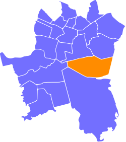
 Location of Giszowiec within Katowice |
|
| Coordinates: 50°13′25″N 19°04′10″E / 50.22361°N 19.06944°ECoordinates: 50°13′25″N 19°04′10″E / 50.22361°N 19.06944°E | |
| Country |
|
| Voivodeship | Silesian |
| County/City | Katowice |
| Area | |
| • Total | 12.03 km2 (4.64 sq mi) |
| Population (2007) | |
| • Total | 18,475 |
| • Density | 1,500/km2 (4,000/sq mi) |
| Time zone | CET (UTC+1) |
| • Summer (DST) | CEST (UTC+2) |
| Area code(s) | (+48) 032 |
Giszowiec (German: Gieschewald) is an eastern district of the city of Katowice (Silesian Voivodeship, Poland), created as a coal miners' settlement in 1907. Initially consisting of about 3,300 miners and their families, the district's population have grown over the years to over 18,000. Although Giszowiec's architectural originality suffered major damages in the 1970s and 1980s due to large scale urbanization, its early unique character can be still felt in the surviving miners' housings, the marketplace, numerous individual buildings and structures, as well as the relatively well preserved general design of a "Garden city".
Giszowiec is located some 7 kilometers southeast from the center of Katowice and its geographical coordinates are 50° 14' N, 19° 04' O coordinates: 50° 14' N, 19° 04' O. Its boundaries are marked in the north by the motorway A4, in the west by the international European route E75, while in the south and in the east, Giszowiec borders the nearby city of Mysłowice. The settlement is somewhat isolated from other Katowice districts and is surrounded by green areas and forests. The neighboring districts are Murcki (3 kilometers to the southwest), as well as Janów and Nikiszowiec in the north.
The settlement of Giszowiec does not have a long history. The company "Georg von Giesches Erben", which in late 19th century owned many mines in Upper Silesia, planned its own settlement for workers, and therefore Colonie Gieschewald was founded 1907.
The leading director of the settlement was Anton Uthemann, who came up with the basic project. This work was completed by George and Emil Zillmann, architects from Charlottenburg, who designed the settlement inspired by Ebenezer Howard's idea of the "Garden city". In just three years the project was completed: high living standard houses for 600 families were built, with four main streets leading to the central marketplace (today called Plac pod Lipami - Square under the Linden Trees). The settlement had its own institutions, a hotel, department stores, a swimming pool and a water tower. Some dwellings were offered to those miners who lived without family. Most inhabitants worked for the Giesche coal mine (today: Wieczorek coal mine), and the total cost of the colony was estimated at 5 million German Marks. In 1914, a narrow-gauge railway to Janów was opened. Throughout its early history the colony was an independent municipality.
...
Wikipedia
