Gloucester River
| Gloucester River | |
| Perennial river | |
|
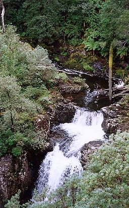
Upper reaches of the Gloucester River, at Gloucester Falls, within Barrington Tops National Park, 1997.
|
|
| Country | Australia |
|---|---|
| State | New South Wales |
| IBRA | NSW North Coast |
| District | Upper Hunter |
| Local government area | Dungog, Mid-Coast Council |
| Part of | Manning River catchment |
| Tributaries | |
| - left | Barrington River, Bowman River |
| - right | Berrico Creek, Buggs Creek, Sandy Creek (Upper Hunter, New South Wales), Avon River |
| Town | Gloucester |
| Landmark | The Bucketts |
| Source | Gloucester Tops, Great Dividing Range |
| - location | north northwest of Dungog |
| - elevation | 1,190 m (3,904 ft) |
| Mouth | confluence with the Manning River |
| - location | west of Wingham |
| - elevation | 38 m (125 ft) |
| Length | 102 km (63 mi) |
| National park | Barrington Tops |
| Waterfall | Gloucester Falls |
Gloucester River (![]() i/ˈɡlɒstər/ GLOS-tər), a perennial river and major tributary of the Manning River catchment, is located in the Upper Hunter district of New South Wales, Australia.
i/ˈɡlɒstər/ GLOS-tər), a perennial river and major tributary of the Manning River catchment, is located in the Upper Hunter district of New South Wales, Australia.
Gloucester River rises within Gloucester Tops, on the eastern slopes of the Great Dividing Range, north northwest of Dungog, and flows generally east northeast, joined by six tributaries including the Avon, Barrington, and Bowman rivers, before reaching its confluence with the Manning River, west of Wingham. The river descends 1,150 metres (3,770 ft) over its 102 kilometres (63 mi) course.
...
Wikipedia

