Glouchestershire
| Gloucestershire | |||
|---|---|---|---|
| County | |||
|
|||
| Motto: Prorsum semper ("Ever forward") | |||
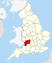
 Gloucestershire in England |
|||
| Coordinates: 51°50′N 2°10′W / 51.833°N 2.167°WCoordinates: 51°50′N 2°10′W / 51.833°N 2.167°W | |||
| Sovereign state |
|
||
| Country |
|
||
| Region | South West | ||
| Established | Ancient | ||
| Ceremonial county | |||
| Lord Lieutenant | Janet Trotter | ||
| High Sheriff | Lt Colonel Andrew J Tabor(2017-18) | ||
| Area | 3,150 km2 (1,220 sq mi) | ||
| • Ranked | 16th of 48 | ||
| Population (mid-2016 est.) | 900,800 | ||
| • Ranked | 23rd of 48 | ||
| Density | 285/km2 (740/sq mi) | ||
| Ethnicity | 91.6% White British | ||
| Non-metropolitan county | |||
| County council |
 Gloucestershire County Council Gloucestershire County Council
|
||
| Executive | Conservative | ||
| Admin HQ | Gloucester | ||
| Area | 2,653 km2 (1,024 sq mi) | ||
| • Ranked | 13th of 27 | ||
| Population | 623,100 | ||
| • Ranked | 19th of 27 | ||
| Density | 234/km2 (610/sq mi) | ||
| ISO 3166-2 | GB-GLS | ||
| ONS code | 23 | ||
| GSS code | E10000013 | ||
| NUTS | UKK13 | ||
| Website | www |
||
| Unitary authorities | |||
| Councils | South Gloucestershire Council | ||
 Districts of Gloucestershire Unitary County council area |
|||
| Districts | |||
| Members of Parliament | List of MPs | ||
| Police | Gloucestershire Constabulary | ||
| Time zone | Greenwich Mean Time (UTC) | ||
| • Summer (DST) | British Summer Time (UTC+1) | ||
Gloucestershire (/ˈɡlɒstərʃər/ (![]() listen), /-ʃɪər/ (
listen), /-ʃɪər/ (![]() listen); formerly abbreviated as Gloucs. in print but now often as Glos.) is a county in South West England. The county comprises part of the Cotswold Hills, part of the flat fertile valley of the River Severn, and the entire Forest of Dean.
listen); formerly abbreviated as Gloucs. in print but now often as Glos.) is a county in South West England. The county comprises part of the Cotswold Hills, part of the flat fertile valley of the River Severn, and the entire Forest of Dean.
...
Wikipedia

