Gloverville, South Carolina
| Gloverville, South Carolina | |
|---|---|
| Census-designated place | |

Gloverville Post Office
|
|
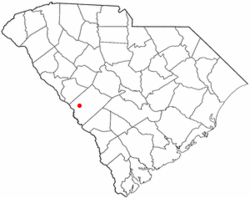
 Location of Gloverville, South Carolina |
|
| Coordinates: 33°31′36″N 81°49′24″W / 33.52667°N 81.82333°WCoordinates: 33°31′36″N 81°49′24″W / 33.52667°N 81.82333°W | |
| Country |
|
| State |
|
| County |
|
| Area | |
| • Total | 3.6 sq mi (9.4 km2) |
| • Land | 3.6 sq mi (9.4 km2) |
| • Water | 0.0 sq mi (0.0 km2) |
| Elevation | 203 ft (62 m) |
| Population (2010) | |
| • Total | 2,831 |
| • Density | 780/sq mi (301.2/km2) |
| Time zone | Eastern (EST) (UTC-5) |
| • Summer (DST) | EDT (UTC-4) |
| ZIP code | 29828 |
| Area code(s) | 803 |
| FIPS code | 45-29410 |
| GNIS feature ID | 1231324 |
Gloverville is a census-designated place (CDP) in Aiken County, South Carolina, United States. The population was 2,831 at the 2010 census. It is part of the Augusta, Georgia metropolitan area. Gloverville is located in historic Horse Creek Valley.
Gloverville is located in western Aiken County at 33°31′36″N 81°49′24″W / 33.52667°N 81.82333°W (33.526665, -81.823352). Neighboring communities are Langley to the southwest, part of Burnettown to the northwest, Graniteville to the north, and Warrenville to the east. Gloverville is located 9 miles (14 km) east of downtown Augusta, Georgia, and 8 miles (13 km) southwest of downtown Aiken.
According to the United States Census Bureau, the Gloverville CDP has a total area of 3.6 square miles (9.4 km2), of which 0.0077 square miles (0.02 km2), or 0.25%, is water.
As of the census of 2000, there were 2,805 people, 1,142 households, and 771 families residing in the CDP. The population density was 801.6 people per square mile (309.4/km²). There were 1,324 housing units at an average density of 378.4/sq mi (146.1/km²). The racial makeup of the CDP was 86.27% White, 10.91% African American, 0.32% Native American, 0.11% Asian, 0.36% from other races, and 2.03% from two or more races. Hispanic or Latino of any race were 1.21% of the population.
...
Wikipedia
