
Gosheim
| Gosheim | ||
|---|---|---|

Gosheim from the Lemberg
|
||
|
||

Gosheim
|
||
|
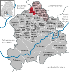
Location of Gosheim within Tuttlingen district
  |
||
| Coordinates: 48°08′04″N 08°45′28″E / 48.13444°N 8.75778°ECoordinates: 48°08′04″N 08°45′28″E / 48.13444°N 8.75778°E | ||
| Country | Germany | |
| State | Baden-Württemberg | |
| Admin. region | Freiburg | |
| District | Tuttlingen | |
| Government | ||
| • Mayor | Bernd Haller | |
| Area | ||
| • Total | 9.32 km2 (3.60 sq mi) | |
| Elevation | 850 m (2,790 ft) | |
| Population (2015-12-31) | ||
| • Total | 3,876 | |
| • Density | 420/km2 (1,100/sq mi) | |
| Time zone | CET/CEST (UTC+1/+2) | |
| Postal codes | 78559 | |
| Dialling codes | 07426 | |
| Vehicle registration | TUT | |
| Website | www.gosheim.de | |

Gosheim is a town in the district of Tuttlingen in Baden-Württemberg in Germany.
Gosheim lies at the foot of the Lemberg, the highest mountain of Swabian Alps. This mountain, at 1,015 metres (3,330 ft), is the highest peak of the range. It is part of the Heuberg plateau. The town boundary lies on the escarpment.
The town is bordered on the north by Deilingen, on the east by Wehingen, on the southeast by Bubsheim and Böttingen, on the south by Denkingen, and on the west by Frittlingen and Wellendingen in the Rottweil district.
The town includes the village of Gosheim and the farmstead of Aumühle.
Traces of settlement from the Hallstatt period have been found. Gosheim first appears in 1295 as Gossheim in a charter of Count Albrecht II of Hohenberg. The village was a dependency (Vogtei) of the castle of Wehingen and from 1351 part of Austria. In 1805 the village was transferred to Württemberg. From 1806 to 1938 Gosheim belonged to the oberamt of Spaichingen, and since 1938 to the Tuttlingen district.
During the Second World War British aircraft dropped heavy bombs within Gosheim's borders on 22 February 1945 at 1400 hours. The bombs fell on Wiesental, Jamit, Täli and on the Sturmbühl. The bombs were intended to destroy the Heuberg Railroad, the former railway line. None hit their intended target, but the harvest was destroyed for several years. The bomb craters were 5–6 metres (16–20 ft) deep and have a diameter of 10–12 metres (33–39 ft). Each bomb ejected and scattered 150–200 cubic metres (5,300–7,100 cu ft) of rock. Even today there are still traces visible. It is believed that three unexploded bombs still remain buried in Wiesental.
...
Wikipedia