Grand View Estates, Colorado
| Grand View Estates, Colorado | |
|---|---|
| Census-designated place | |
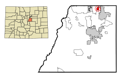
 Location in Douglas County and the state of Colorado |
|
| Coordinates: 39°32′37″N 104°49′19″W / 39.54361°N 104.82194°WCoordinates: 39°32′37″N 104°49′19″W / 39.54361°N 104.82194°W | |
| Country |
|
| State |
|
| County | Douglas |
| Area | |
| • Total | 0.8 sq mi (2.2 km2) |
| • Land | 0.8 sq mi (2.2 km2) |
| • Water | 0 sq mi (0 km2) |
| Elevation | 5,814 ft (1,772 m) |
| Population (2010) | |
| • Total | 528 |
| • Density | 624/sq mi (240.8/km2) |
| Time zone | MST (UTC-7) |
| • Summer (DST) | MDT (UTC-6) |
| ZIP code | 80134 (Parker) |
| FIPS code | 08-31935 |
| GNIS feature ID | 0185049 |
Grand View Estates is an unincorporated community and census-designated place (CDP) in Douglas County, Colorado, United States. The population was 528 at the 2010 census.
Grand View Estates is located in northern Douglas County at 39°32′37″N 104°49′19″W / 39.54361°N 104.82194°W (39.543738, -104.821856), between Stonegate and Parker to the east and Lone Tree to the west. It is just south of Exits 2 and 3 on the E-470 toll highway and is 20 miles (32 km) south of downtown Denver.
According to the United States Census Bureau, the CDP has a total area of 0.85 square miles (2.2 km2), all of it land.
As of the census of 2000, there were 691 people, 243 households, and 201 families residing in the CDP. The population density was 546.4 people per square mile (211.7/km²). There were 244 housing units at an average density of 192.9 per square mile (74.8/km²). The racial makeup of the CDP was 95.51% White, 1.01% African American, 0.29% Native American, 0.58% Asian, 0.72% from other races, and 1.88% from two or more races. Hispanic or Latino of any race were 3.04% of the population.
...
Wikipedia
