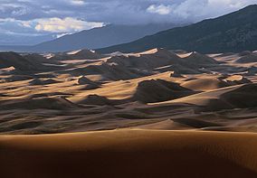
Great Sand Dunes National Park
| Great Sand Dunes National Park and Preserve | |
|---|---|
|
IUCN category II (national park)
|
|

Great Sand Dunes
|
|
| Location | Saguache County and Alamosa County, Colorado, USA |
| Nearest city | Alamosa |
| Coordinates | 37°43′58″N 105°30′44″W / 37.732870°N 105.512120°WCoordinates: 37°43′58″N 105°30′44″W / 37.732870°N 105.512120°W |
| Area | 84,997 acres (343.97 km2) |
| Established | September 13, 2004 |
| Visitors | 388,308 (in 2016) |
| Governing body | National Park Service |
| Website | Great Sand Dunes National Park and Preserve |
Great Sand Dunes National Park and Preserve is a United States National Park located in the San Luis Valley, in the easternmost parts of Alamosa County and Saguache County, Colorado, United States. Originally created as Great Sand Dunes National Monument on March 17, 1932, Great Sand Dunes National Park and Preserve was established by an act of the United States Congress on September 13, 2004. The park includes 44,246 acres (17,906 ha), and the preserve protects an additional 41,686 acres (16,870 ha).
The park contains the tallest sand dunes in North America, rising to a maximum height of 750 feet (229 m) from the floor of the San Luis Valley on the western base of the Sangre de Cristo Range, covering about 19,000 acres (7,700 ha). Researchers say that the dunes started forming less than 440,000 years ago.
The dunes were formed from sand and soil deposits of the Rio Grande and its tributaries, flowing through the San Luis Valley. Over the ages, glaciers feeding the river and the vast lake that existed upon the valley melted, and the waters evaporated. Westerly winds picked up sand particles from the lake and river flood plain. As the wind lost power before crossing the Sangre de Cristo Range, the sand was deposited on the east edge of the valley. This process continues, and the dunes are slowly growing. The wind changes the shape of the dunes daily.
There are several streams flowing on the perimeter of the dunes. The streams erode the edge of the dune field, and sand is carried downstream. The water disappears into the ground, depositing sand on the surface. Winds pick up the deposits of sand, and blow them up onto the dune field once again.
Digging a couple inches into the dunes even at their peaks reveals wet sand. Part of the motivation of turning the Monument into a National Park was the extra protection of the water, which Colorado's cities and agriculture covet.
...
Wikipedia

