Gum Springs, Arkansas
| Gum Springs, Arkansas | |
|---|---|
| Town | |
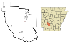
 Location in Clark County and the state of Arkansas |
|
| Coordinates: 34°3′45″N 93°5′58″W / 34.06250°N 93.09944°WCoordinates: 34°3′45″N 93°5′58″W / 34.06250°N 93.09944°W | |
| Country | United States |
| State | Arkansas |
| County | Clark |
| Area | |
| • Total | 0.40 sq mi (1.04 km2) |
| • Land | 0.40 sq mi (1.04 km2) |
| • Water | 0 sq mi (0 km2) |
| Elevation | 210 ft (64 m) |
| Population (2010) | |
| • Total | 120 |
| • Density | 299/sq mi (115.3/km2) |
| Time zone | Central (CST) (UTC-6) |
| • Summer (DST) | CDT (UTC-5) |
| ZIP code | 71923 |
| Area code(s) | 870 |
| FIPS code | 05-29140 |
| GNIS feature ID | 0077091 |
Gum Springs is a town in Clark County, Arkansas, United States. The population was 120 at the 2010 census, down from 194 at the 2000 census.
Gum Springs is located northeast of the center of Clark County at 34°3′45″N 93°5′58″W / 34.06250°N 93.09944°W (34.062631, -93.099495).U.S. Route 67 passes through the town, leading northeast 5 miles (8 km) to Arkadelphia, the county seat, and southwest 10 miles (16 km) to Gurdon. Interstate 30 passes northwest of the town, with access from Exit 69.
According to the United States Census Bureau, Gum Springs has a total area of 0.40 square miles (1.04 km2), all land.
As of the census of 2000, there were 194 people, 87 households, and 54 families residing in the town. The population density was 187.3/km² (483.8/mi²). There were 100 housing units at an average density of 96.5/km² (249.4/mi²). The racial makeup of the town was 44.85% White and 55.15% Black or African American. 4.64% of the population were Hispanic or Latino of any race.
...
Wikipedia
