Gungahlin (district)
|
Gungahlin Australian Capital Territory |
|||||||||||||
|---|---|---|---|---|---|---|---|---|---|---|---|---|---|

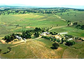
Gold Creek was typical of the sheep properties of the Gungahlin region prior to development.
|
|||||||||||||

Location of Gungahlin, shaded.
|
|||||||||||||
| Coordinates | 35°10′59″S 149°07′59″E / 35.1831°S 149.133°ECoordinates: 35°10′59″S 149°07′59″E / 35.1831°S 149.133°E | ||||||||||||
| Population | 46,971 (2011 census) | ||||||||||||
| • Density | 518.44/km2 (1,342.8/sq mi) | ||||||||||||
| Gazetted | 12 May 1966 | ||||||||||||
| Area | 90.6 km2 (35.0 sq mi) | ||||||||||||
| Location | 10 km (6 mi) N of Canberra City | ||||||||||||
| Territory electorate(s) | Yerrabi | ||||||||||||
| Federal Division(s) | Fenner | ||||||||||||
|
|||||||||||||
The District of Gungahlin is one of the original eighteen districts of the Australian Capital Territory used in land administration. The district is subdivided into divisions (suburbs), sections and blocks. Gungahlin is an Aboriginal word meaning "little rocky hill".
As of 2013[update] Gungahlin comprised eleven suburbs, including three currently under construction and a further seven suburbs planned. The town of Gungahlin was part of the original 1957 plan for future development in the ACT and in 1991 was officially launched as Canberra’s fourth ‘town’ by the ACT Chief Minister. At the time, the population of Gungahlin was just 389 residents. At the 2011 census, the population of the district was 46,971; and this figure is expected to rise to 60,000 by the year 2016; and to grow to 72,900 by 2021.
Within the district is Canberra's northernmost town centre that is situated 10 kilometres (6.2 mi) north of Canberra city centre. The town centre is one of five satellites of Canberra, seated in Woden, Tuggeranong, Weston Creek and Belconnen.
The traditional custodians of the district are the indigenous people of the Ngunawal tribe.
Following the transfer of land from the Government of New South Wales to the Commonwealth Government in 1911, the district was established in 1966 by the Commonwealth via the gazettal of the Districts Ordinance 1966 No. 5 (Cth) which, after the enactment of the Australian Capital Territory (Self-Government) Act 1988 (Cth), became the Districts Act 1966 No. 5 (ACT). This Act was subsequently repealed by the ACT Government and the district is now administered subject to the Districts Act 2002 (ACT).
...
Wikipedia
