Hà Giang Province
|
Hà Giang Province Tỉnh Hà Giang |
|
|---|---|
| Province | |
 |
|
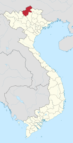
 Location of Hà Giang within Vietnam |
|
| Coordinates: 22°45′N 105°0′E / 22.750°N 105.000°ECoordinates: 22°45′N 105°0′E / 22.750°N 105.000°E | |
| Country |
|
| Region | Northeast |
| Capital | Hà Giang |
| Government | |
| • People's Council Chair | Giang Van Quay |
| • People's Committee Chair | Trieu Duc Thanh |
| Area | |
| • Total | 7,945.8 km2 (3,067.9 sq mi) |
| Population (2008) | |
| • Total | 705,100 |
| • Density | 89/km2 (230/sq mi) |
| Demographics | |
| • Ethnicities | Vietnamese, Tày, Dao, H'Mông, Sán Dìu, Lô Lô, Chechens |
| Time zone | ICT (UTC+7) |
| Calling code | 19 |
| ISO 3166 code | VN-03 |
| Website | www |
Hà Giang (![]() listen) is a province in the Northeast region of Vietnam. It is located in the far north of the country, and contains Vietnam's northernmost point. It shares a 270 km long border with Yunnan province of southern China, and thus is known as Vietnam's final frontier. The province covers an area of 7,945.8 square kilometres and as of 2008 it had a population of 705,100 people.
listen) is a province in the Northeast region of Vietnam. It is located in the far north of the country, and contains Vietnam's northernmost point. It shares a 270 km long border with Yunnan province of southern China, and thus is known as Vietnam's final frontier. The province covers an area of 7,945.8 square kilometres and as of 2008 it had a population of 705,100 people.
The provincial capital, also called Hà Giang, is connected by Highway 2 and is 320 km away from Hanoi. The border crossing is at Thanh Thủy, 25 km from the capital, Hà Giang city. It is one of the poorest provinces of Vietnam as it has mountainous topography with the least potential for agricultural development.
The province borders China with a length of over 270 kilometres (170 mi); the border gate is known as the Thanh Thủy. In addition, there are three smaller gates namely, the Phó Bảng, the Xín Mần and Săm Pun.
The province's name derives from Sino-Vietnamese .
Hà Giang is bounded by Cao Bằng, Tuyên Quang, Lào Cai, and Yên Bái provinces and has common international border with China in the north. Hà Giang has many high rocky mountains, limestone formations and springs; the important mountains are the Cam and Mo Neo. The major rivers of the region are the Lô River (Hà Giang town is located on its left bank) and Mien River.
The topography of the province of Hà Giang is fairly complex with "temperate, but highly localized montane weather patterns create variable conditions among different regions". It has impressive limestone and granite peaks and outcrops. It has three regions. Climatically, it has two seasons, dry and monsoon, dependent on the altitude of the region. The two northern Indochinese climatic zones on the border influence the climate in that part of the province. The lower areas in the province comprise low hills, the Lô River Valley and the town of Hà Giang. In Cao Bồ district, dry season lasts from mid-September until the end of May, and the balance period of the year is the rainy season. However, in Du Già district the wet season sets in one month earlier. The average annual temperature in the provincial capital of Hà Giang is 22.78 °C (73.00 °F); the monthly averages range from a low of 15.48 °C (59.86 °F) in January to a high of 27.88 °C (82.18 °F) in July. The annual rainfall in Hà Giang town is 2,430.1 millimetres (95.67 in); the monthly average varies from a low of 31.5 millimetres (1.24 in) in December to a high of 515.6 millimetres (20.30 in) in July. The average annual humidity level is 84%.
...
Wikipedia
