Haberfield, New South Wales
|
Haberfield Sydney, New South Wales |
|||||||||||||
|---|---|---|---|---|---|---|---|---|---|---|---|---|---|

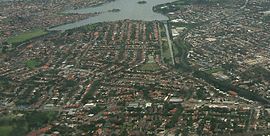
Aerial photograph of Haberfield
|
|||||||||||||
| Population | 6,650 (2011 census) | ||||||||||||
| Postcode(s) | 2045 | ||||||||||||
| Location | 9 km (6 mi) west of Sydney CBD | ||||||||||||
| LGA(s) | Inner West Council | ||||||||||||
| State electorate(s) | Summer Hill | ||||||||||||
| Federal Division(s) | Grayndler | ||||||||||||
|
|||||||||||||
Haberfield is a suburb in the Inner West of Sydney, in the state of New South Wales, Australia. Haberfield is located 9 kilometres west of the Sydney central business district in the local government area of the Inner West Council.
Haberfield sits south of Iron Cove, which is part of Sydney Harbour. It is bounded to the east by the Hawthorne canal, to the northwest by the Iron Cove Creek canal and to the southwest by Parramatta Road. Its main road is Ramsay Street and the point of land that faces Iron Cove, Dobroyd Point, is a historical locality of Sydney. Haberfield was dubbed "the garden suburb" in the early 20th century and retains its well-kept parks, tree-lined streets and fine Federation-era houses with immaculate gardens. The entire suburb is heritage-listed. It is also known for its Italian culture.
Haberfield was named by early landholder Richard Stanton, after his wife's maiden name.
The area of which is now known as Haberfield was part of the broader area which lived people from the Darug tribe known variously as the Wangals or Cadigals from the Eora nation. There is no specific evidence of indigenous settlement in the area. However, the area that is now Haberfield was one of the last areas in the inner-west to be developed so, in the late 19th century it again became a home to local kooris.
Nicholas Bayly, a soldier, received the first land grant in the area in 1803 but sold it two years later to Simeon Lord who called it Dobroyde Estate. Lord gave the land to his daughter Sarah Ann and her new husband David Ramsay as a wedding present in 1825 and it stayed in the hands of the Ramsay family until the end of the century. The Ramsays developed orchards in the area and built a number of fine houses for various members of the family including Yasmar (Ramsay spelt backwards) and St David's Presbyterian church. They also created four of the suburb's current streets: Ramsay Street, Dalhousie Street (named after the Ramsay's historic home in Scotland), Boomerang Street and Waratah Street.
...
Wikipedia
