Haerlem
| Haarlem | |||
|---|---|---|---|
| City and municipality | |||

Grote Kerk ("Great Church") on the Grote Markt, Haarlem's central square
|
|||
|
|||
| Nickname(s): Bloemenstad, Spaarnestad | |||
| Motto: Vicit vim virtus (Virtue conquered force) | |||
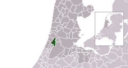
 Location in North Holland |
|||
| Coordinates: 52°23′N 4°38′E / 52.383°N 4.633°ECoordinates: 52°23′N 4°38′E / 52.383°N 4.633°E | |||
| Country | Netherlands | ||
| Province | North Holland | ||
| Government | |||
| • Body | Municipal council | ||
| • Mayor | Jos Wienen (CDA) | ||
| Area | |||
| • Municipality | 32.09 km2 (12.39 sq mi) | ||
| • Land | 29.22 km2 (11.28 sq mi) | ||
| • Water | 2.87 km2 (1.11 sq mi) | ||
| Elevation | 2 m (7 ft) | ||
| Population (Municipality, February 2017; Urban and Metro, May 2014) | |||
| • Municipality | 155,758 | ||
| • Density | 5,331/km2 (13,810/sq mi) | ||
| • Urban | 204,429 | ||
| • Metro | 420,447 | ||
| Demonym(s) | Haarlemmer | ||
| Time zone | CET (UTC+1) | ||
| • Summer (DST) | CEST (UTC+2) | ||
| Postcode | 2000–2037, 2063 | ||
| Area code | 023 | ||
| Website | www |
||
Haarlem (Dutch pronunciation: [ˈɦaːrlɛm]; predecessor of Harlem in the English language) is a city and municipality in the Netherlands. It is the capital of the province of North Holland and is situated at the northern edge of the Randstad, one of the most populated metropolitan areas in Europe. Haarlem had a population of 155,758 in 2017. It is a 15-minute train ride from Amsterdam, and many residents commute to the country's capital for work.
Haarlem was granted city status or stadsrechten in 1245, although the first city walls were not built until 1270. The modern city encompasses the former municipality of Schoten as well as parts that previously belonged to Bloemendaal and Heemstede. Apart from the city, the municipality of Haarlem also includes the western part of the village of Spaarndam. Newer sections of Spaarndam lie within the neighbouring municipality of Haarlemmerliede en Spaarnwoude.
The city is located on the river Spaarne, about 20 km (12 mi) west of Amsterdam and near the coastal dunes. It has been the historical centre of the tulip bulb-growing district for centuries and bears the nickname 'Bloemenstad' (flower city), for this reason.
...
Wikipedia


