Haihe River
| Hai River (海河) | |
| Hai He | |
|
Hai River in Tianjin
|
|
| Country | China |
|---|---|
| States | Tianji, Hebei, Beijing, Henan, Inner Mongolia, Shanxi, Shandong |
| Source | Taihang Mountains、Yan Mountains |
| Mouth | Bohai Sea |
| Length | 1,329 km (826 mi) |
| Basin | 318,200 km2 (122,858 sq mi) |
| Discharge | |
| - average | 717 m3/s (25,321 cu ft/s) |
|
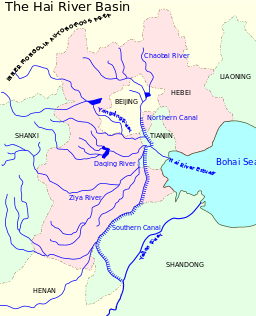
Hai River basin
|
|
| Hai River | |||||||
| Chinese | |||||||
|---|---|---|---|---|---|---|---|
| Literal meaning | Sea River | ||||||
|
|||||||
| Peiho | |||||||
| Chinese | |||||||
| Literal meaning | White River | ||||||
|
|||||||
| Transcriptions | |
|---|---|
| Standard Mandarin | |
| Hanyu Pinyin | Hǎi Hé |
| Transcriptions | |
|---|---|
| Standard Mandarin | |
| Hanyu Pinyin | Bái Hé |
The Hai River, formerly known as the Peiho or Pei Ho, is a Chinese river connecting Beijing to Tianjin and the Bohai Sea.
The Hai River at Tianjin is formed by the confluence of five rivers, the Southern Canal, Ziya River, Daqing River, Yongding River, and the Northern Canal. The southern and northern canals are parts of the Grand Canal. The Southern Canal is joined by the Wei River at Linqing. The Northern Canal joins with the Bai He (or Chaobai River) at Tongzhou. The Northern Canal (sharing a channel with Bai He) is also the only waterway from the sea to Beijing. Therefore, early Westerners also called the Hai He the Bai He.
At Tianjin, through the Grand Canal, the Hai connects with the Yellow and Yangtze rivers. The construction of the Grand Canal greatly altered the rivers of the Hai He basin. Previously, the Wei, Ziya Yongding and Bai Rivers flowed separately to the sea. The Grand Canal cut through the lower reaches of these rivers and fused them into one outlet to the sea, in the form of the current Hai He.
Hai He is 1,329 kilometres (826 mi) long measured from the longest tributary. However, the Hai He is only around 70 kilometres (43 mi) from Tianjin to its estuary. Its basin has an area of approximately 319,000 km2 (123,000 sq mi). Its annual flow is only half that of the Yellow River, or one-thirtieth that of the Yangtze River.
In 1863 seagoing ships could reach the head of navigation at Tongzhou, but the crooked river was difficult for large vessels. During the Boxer Rebellion, Imperial Chinese forces deployed a weapon called "electric mines" on June 15, at the Baihe river before the Battle of Dagu Forts (1900), to prevent the western Eight-Nation Alliance from sending ships to attack. This was reported by American military intelligence in the United States. War Dept. by the United States. Adjutant-General's Office. Military Information Division.
...
Wikipedia


