Hammonton, New Jersey
| Hammonton, New Jersey | |
|---|---|
| Town | |
| Town of Hammonton | |

William L. Black House
|
|
| Nickname(s): "Blueberry Capital of the World" | |
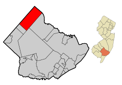
 Map of Hammonton in Atlantic County |
|
 Census Bureau map of Hammonton, New Jersey |
|
| Coordinates: 39°39′39″N 74°46′01″W / 39.66078°N 74.767021°WCoordinates: 39°39′39″N 74°46′01″W / 39.66078°N 74.767021°W | |
| Country |
|
| State |
|
| County | Atlantic |
| Incorporated | March 5, 1866 |
| Named for | John Hammond Coffin |
| Government | |
| • Type | Town |
| • Body | Town Council |
| • Mayor | Stephen DiDonato (term ends December 31, 2017) |
| • Clerk | April Boyer Maimone |
| Area | |
| • Total | 41.419 sq mi (107.274 km2) |
| • Land | 40.887 sq mi (105.897 km2) |
| • Water | 0.532 sq mi (1.377 km2) 1.28% |
| Area rank | 50th of 566 in state 7th of 23 in county |
| Elevation | 62 ft (19 m) |
| Population (2010 Census) | |
| • Total | 14,791 |
| • Estimate (2015) | 14,618 |
| • Rank | 169th of 566 in state 6th of 23 in county |
| • Density | 361.8/sq mi (139.7/km2) |
| • Density rank | 464th of 566 in state 15th of 23 in county |
| Time zone | Eastern (EST) (UTC-5) |
| • Summer (DST) | Eastern (EDT) (UTC-4) |
| ZIP code | 08037 |
| Area code(s) | 609 |
| FIPS code | 3400129430 |
| GNIS feature ID | 0885242 |
| Website | www |
Hammonton is a town in Atlantic County, New Jersey, United States, known as the "Blueberry Capital of the World." As of the 2010 United States Census, the town's population was 14,791, reflecting an increase of 2,187 (+17.4%) from the 12,604 counted in the 2000 Census, which had in turn increased by 396 (+3.2%) from the 12,208 counted in the 1990 Census.
Hammonton was settled in 1812 and was named for John Hammond Coffin, a son of one of the community's earliest settlers, William Coffin, with the "d" in what was originally "Hammondton" disappearing over time. It was incorporated as a town by an act of the New Jersey Legislature on March 5, 1866, from portions of Hamilton Township and Mullica Township. It is located directly between Philadelphia and the resort town of Atlantic City, along a former route of the Pennsylvania Railroad that is used by NJ Transit's Atlantic City Line.
According to the United States Census Bureau, the town had a total area of 41.419 square miles (107.274 km2), including 40.887 square miles (105.897 km2) of land and 0.532 square miles (1.377 km2) of water (1.28%).
The town borders Folsom borough, to the southwest, and both Hamilton and Mullica townships to the southeast in Atlantic County; Shamong Township and Washington Township in Burlington County to the northeast; and Waterford Township and Winslow Township in Camden County to the northwest. It is located in the Atlantic Coastal Plain, so is largely flat, though the highest point in Atlantic County is located along the Pennsylvania Railroad within the borders of Hammonton. The town is located almost exactly halfway between Philadelphia and Atlantic City.
...
Wikipedia
