Harlingen, New Jersey
| Harlingen, New Jersey | |
|---|---|
| Census-designated place | |

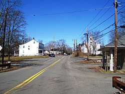
Harlingen as seen from westbound Harlingen Road
|
|
| Location of Harlingen within Somerset County. (Inset: Location of Somerset County in New Jersey). | |
| Coordinates: 40°26′58″N 74°39′31″W / 40.449363°N 74.658505°WCoordinates: 40°26′58″N 74°39′31″W / 40.449363°N 74.658505°W | |
| Country |
|
| State |
|
| County | Somerset |
| Township | Montgomery |
| Area | |
| • Total | 0.717 sq mi (1.858 km2) |
| • Land | 0.717 sq mi (1.858 km2) |
| • Water | 0.000 sq mi (0.000 km2) 0.00% |
| Elevation | 79 ft (24 m) |
| Population (2010 Census) | |
| • Total | 280 |
| • Density | 414.1/sq mi (159.9/km2) |
| Time zone | Eastern (EST) (UTC-5) |
| • Summer (DST) | Eastern (EDT) (UTC-4) |
| Area code(s) | 609 and 732/848 |
| FIPS code | 3429940 |
| GNIS feature ID | 02584000 |
Harlingen is an unincorporated community and census-designated place (CDP) located within Montgomery Township, in Somerset County, New Jersey, United States. As of the 2010 United States Census, the CDP's population was 297.
It is adjacent to the historical areas of Dutchtown and Bridgepoint. Harlingen Road and U.S. Route 206 intersect in the center of Harlingen. The Harlingen Dutch Reformed Church on Route 206 is extant and had an associated cemetery. The town was a stop on the short-lived Mercer and Somerset Railway.
According to the United States Census Bureau, Harlingen had a total area of 0.717 square miles (1.858 km2), all of which was land.
As of the 2010 United States Census, there were 297 people, 93 households, and 81 families residing in the CDP. The population density was 414.1 per square mile (159.9/km2). There were 98 housing units at an average density of 136.6 per square mile (52.7/km2). The racial makeup of the CDP was 77.78% (231) White, 1.68% (5) Black or African American, 0.00% (0) Native American, 16.50% (49) Asian, 0.00% (0) Pacific Islander, 2.36% (7) from other races, and 1.68% (5) from two or more races. Hispanic or Latino of any race were 5.72% (17) of the population.
...
Wikipedia


