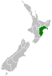
Hawke's Bay, New Zealand
| Hawke's Bay | |
| Country: | New Zealand |
| Regional council | |
|---|---|
| Name: | Hawke's Bay Regional Council |
| Seat: | Napier |
| Largest city: | Hastings |
| Population: | 161,500 June 2016 |
| Land area: | 14,111 km² |
| Chair: | Rex Graham |
| Deputy chair: | Rick Barker |
| Website: | http://www.hbrc.govt.nz/ |
| Cities and towns | |
| Cities: | Hastings • Napier |
| Towns and other settlements: | Bridge Pa • Clive • Frasertown • Haumoana • Mahia Beach • Maraekakaho • Nuhaka • Ocean Beach • Ongaonga • Otane • Takapau • Te Awanga • Tikokino • Tuai • Tutira • Waimarama • Waipawa • Waipukurau • Wairoa |
| Territorial authorities | |
| Names: |
Central Hawke's Bay Hastings District Napier City Wairoa District |
| Geographic figures | |
| Land area: | 14,111 km² |
| Coastline: | 360 km |
| Highest point: | Mount Mangaweka 1,733m |
| Longest river: | Mohaka River 174 km |
| Largest lake: | Lake Waikaremoana 54 km² |
Coordinates: 39°25′S 176°49′E / 39.417°S 176.817°E
Hawke's Bay Region (Māori: Heretaunga) is a region of New Zealand on the east coast of the North Island. It is recognised on the world stage for its award-winning wines. Hawke's Bay Regional Council sits in both the cities of Napier and Hastings. It derives from Hawke Bay which was named by Captain James Cook in honour of Admiral Edward Hawke who decisively defeated the French at the Battle of Quiberon Bay in 1759.
The region is situated on the east coast of the North Island. It bears the former name of what is now Hawke Bay, a large semi-circular bay that extends for 100 kilometres from northeast to southwest from Mahia Peninsula to Cape Kidnappers.
The Hawke's Bay region includes the hilly coastal land around the northern and central bay, the floodplains of the Wairoa River in the north, the wide fertile Heretaunga Plains around Hastings in the south, and a hilly interior stretching up into the Kaweka and Ruahine Ranges.
...
Wikipedia

