Hellendoorn
| Hellendoorn | |||
|---|---|---|---|
| Municipality | |||

looking toward the Hellendoorn town centre
|
|||
|
|||
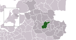
 Location in Overijssel |
|||
| Coordinates: 52°22′N 6°28′E / 52.367°N 6.467°ECoordinates: 52°22′N 6°28′E / 52.367°N 6.467°E | |||
| Country | Netherlands | ||
| Province | Overijssel | ||
| Government | |||
| • Body | Municipal council | ||
| • Mayor | Anneke Raven (CDA) | ||
| Area | |||
| • Total | 138.99 km2 (53.66 sq mi) | ||
| • Land | 138.07 km2 (53.31 sq mi) | ||
| • Water | 0.92 km2 (0.36 sq mi) | ||
| Elevation | 10 m (30 ft) | ||
| Population (February 2017) | |||
| • Total | 35,682 | ||
| • Density | 258/km2 (670/sq mi) | ||
| Time zone | CET (UTC+1) | ||
| • Summer (DST) | CEST (UTC+2) | ||
| Postcode | 7440–7449, 7687–7689 | ||
| Area code | 0546, 0548 | ||
| Website | www |
||
Hellendoorn (![]() pronunciation ) is a municipality and a town in the middle of the Dutch province of Overijssel.
pronunciation ) is a municipality and a town in the middle of the Dutch province of Overijssel.
There is an amusement park near the town of Hellendoorn called Avonturenpark Hellendoorn.
The municipality comprises:
Towns:
Hamlets:
Dutch topographic map of the municipality of Hellendoorn, June 2015
The central part of the municipality consists of a hilly and sparsely populated area that extends south into the municipality of Rijssen-Holten, called the Sallandse Heuvelrug (Salland Ridge). The highest point lies at about 70 metres (230 ft) above sea level and is part of the Noetselerberg. A large chunk of the area is covered by forest, but there are also heathlands. This scenery is now part of the Sallandse Heuvelrug National Park.
...
Wikipedia


