Henlopen Acres, Delaware
| Henlopen Acres, Delaware | |
|---|---|
| Town | |
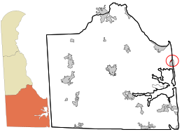
 Location in Sussex County and the state of Delaware. |
|
| Location within the state of Delaware | |
| Coordinates: 38°43′47″N 75°05′11″W / 38.72972°N 75.08639°WCoordinates: 38°43′47″N 75°05′11″W / 38.72972°N 75.08639°W | |
| Country | United States |
| State | Delaware |
| County | Sussex |
| Area | |
| • Total | 0.26 sq mi (0.66 km2) |
| • Land | 0.26 sq mi (0.66 km2) |
| • Water | 0.00 sq mi (0.00 km2) |
| Elevation | 3 ft (0.9 m) |
| Population (2010) | |
| • Total | 122 |
| • Estimate (2016) | 138 |
| • Density | 541.18/sq mi (208.69/km2) |
| Time zone | Eastern (EST) (UTC-5) |
| • Summer (DST) | EDT (UTC-4) |
| Area code(s) | 302 |
| FIPS code | 10-33900 |
| GNIS feature ID | 214078 |
Henlopen Acres is a municipality north of Rehoboth Beach in Sussex County, Delaware, United States, and is the third smallest incorporated town in Delaware. According to 2010 census figures, the population of the town is 122, a decrease of 12.2% from the 2000 census. It is part of the Salisbury, Maryland-Delaware Metropolitan Statistical Area.
Henlopen Acres is located at 38°43′47″N 75°05′11″W / 38.72972°N 75.08639°W (38.7298343, -75.0862919).
According to the United States Census Bureau, the town has a total area of 0.3 square miles (0.7 km²), all of it land. It is the smallest incorporated town in Delaware. It borders the Atlantic Ocean to the northeast, Rehoboth Beach to the southeast, and unincorporated portions of Sussex County on the west and north. Much of its western border is demarcated by the Lewes and Rehoboth Canal. An unincorporated neighborhood called North Shores separates the northernmost part of Henlopen Acres from the southern boundary of Cape Henlopen State Park.
Henlopen Acres is divided into 216 parcels of land, on which are 205 homes, the town hall and maintenance area, the town's marina, the Henlopen Acres Beach Club, Block W Beach, and the Rehoboth Art League. The town has 3.6 miles (5.8 kilometers) of roads, which generally are tree-lined.
...
Wikipedia


