Hewlett Harbor, New York
| Hewlett Harbor, New York | |
|---|---|
| Village | |
| Village of Hewlett Harbor | |
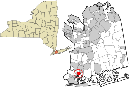
 Location in Nassau County and the state of New York. |
|
| Location within the state of New York | |
| Coordinates: 40°38′6″N 73°40′58″W / 40.63500°N 73.68278°WCoordinates: 40°38′6″N 73°40′58″W / 40.63500°N 73.68278°W | |
| Country | United States |
| State | New York |
| County | Nassau |
| Area | |
| • Total | 0.8 sq mi (2.1 km2) |
| • Land | 0.7 sq mi (1.9 km2) |
| • Water | 0.1 sq mi (0.2 km2) |
| Elevation | 10 ft (3 m) |
| Population (2010) | |
| • Total | 1,263 |
| Time zone | Eastern (EST) (UTC-5) |
| • Summer (DST) | EDT (UTC-4) |
| ZIP code | 11557 |
| Area code(s) | 516 |
| FIPS code | 36-34308 |
| GNIS feature ID | 0970203 |
| Website | www |
Hewlett Harbor is a village in Nassau County, New York in the USA. The population was 1,263 as of the 2010 census.
The Village of Hewlett Harbor is located within the Town of Hempstead. This area, like Back/Old is unique because its rural affluence is similar in character to the more well known Gold Coast of the North Shore instead of being more urbanized like the rest of the South Shore of Nassau County.
Hewlett Harbor is located at 40°38′06″N 73°40′58″W / 40.634927°N 73.682669°W.
According to the United States Census Bureau, the village has a total area of 0.8 square miles (2.1 km2), of which, 0.7 square miles (1.8 km2) of it is land and 0.1 square miles (0.26 km2) of it (10.98%) is water.
The community is served by the Hewlett-Woodmere School District and the Lynbrook Union Free School District.
As of the census of 2000, there were 1,271 people, 429 households, and 380 families residing in the village. The population density was 1,754.3 people per square mile (681.6/km2). There were 437 housing units at an average density of 603.2 per square mile (234.3/km2). The racial makeup of the village was 95.12% White, 0.39% African American, 0.16% Native American, 3.15% Asian, 0.63% from other races, and 0.55% from two or more races. Hispanic or Latino of any race were 1.10% of the population.
...
Wikipedia

