High Fens
| High Fens | |
|---|---|

The Fens landscape near the German border
|
|
| Map of the High Fens | |
| Location | Liège, in Belgium and also in nearby parts of Germany, between the Ardennes and the Eifel |
| Coordinates | 50°32′40″N 6°4′40″E / 50.54444°N 6.07778°ECoordinates: 50°32′40″N 6°4′40″E / 50.54444°N 6.07778°E |
| Area | 4,501.2 ha (17.379 sq mi) |
| Established | 1957 as Nature Reserve |
| Website | [1] |
The High Fens (French: Hautes Fagnes; German: Hohes Venn; Dutch: Hoge Venen), which were declared a nature reserve in 1957, are an upland area, a plateau region in the province of Liège, in the east of Belgium and adjoining parts of Germany, between the Ardennes and the Eifel highlands. The High Fens are the largest nature reserve or park in Belgium, with an area of 4,501.2 hectares (11,123 acres); it lies within the German-Belgian natural park Hohes Venn-Eifel (700 square kilometres (270 sq mi)), in the Ardennes. Its highest point, at 694 metres (2,277 ft) above sea level, is the Signal de Botrange near Eupen, and also the highest point in Belgium. A tower 6 metres (20 ft) high was built here that reaches 700 metres (2,297 ft) above sea level. The reserve is a rich ecological endowment of Belgium covered with alpine sphagnum raised bogs (not "fens" as the name would imply) both on the plateau and in the valley basin; the bogs, which are over 10,000 years old, with their unique subalpine flora, fauna and microclimate, are key to the conservation work of the park.
In 1966, the European Council awarded the "Diploma of Conservation" to the High Fens, for their ecological value.
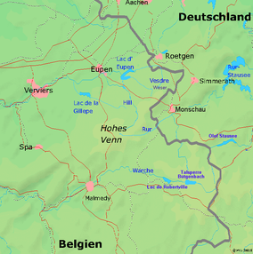
The High Fens, established as a reserve in 1957, with their high relief and unique location, consist mainly of raised bogs, and low, grass- or wood-covered hills, moorland and forest. The provincial capital of Liège is to its west, the German border is to the east and the dark forested hills of the Ardennes surround the southern part. The park stretches between Eupen in the north, Monschau in the east, Spa in the west and Malmedy in the south. It stretches north of Malmedy as far as Eupen and marks the end of the Ardennes proper. It is contiguous with the Eifel hills, which stretch east from the German border to form the large Deutsch–Belgischer Naturpark. Signal de Botrange located in the Haute Fagnes is marked by a Telecom Tower erected over an older artificial, earthen mound with stone steps that was built to raise a small part of the broad plateau from 694–700 metres (2,277–2,297 ft). Large urban centres in the vicinity of the reserve are Eupen, Verviers, Spa and Malmedy.
...
Wikipedia

