Hobøl
| Hobøl kommune | |||
|---|---|---|---|
| Municipality | |||
|
|||
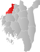
 Hobøl within Østfold |
|||
| Coordinates: 59°35′35″N 10°56′45″E / 59.59306°N 10.94583°ECoordinates: 59°35′35″N 10°56′45″E / 59.59306°N 10.94583°E | |||
| Country | Norway | ||
| County | Østfold | ||
| Administrative centre | Elvestad | ||
| Government | |||
| • Mayor (2007) | Kjell Håvard Jensen (FrP) | ||
| Area | |||
| • Total | 140 km2 (50 sq mi) | ||
| • Land | 139 km2 (54 sq mi) | ||
| Area rank | 365 in Norway | ||
| Population (2004) | |||
| • Total | 4,504 | ||
| • Rank | 214 in Norway | ||
| • Density | 32/km2 (80/sq mi) | ||
| • Change (10 years) | 13.4 % | ||
| Demonym(s) | Hobøling or Hobling |
||
| Time zone | CET (UTC+1) | ||
| • Summer (DST) | CEST (UTC+2) | ||
| ISO 3166 code | NO-0138 | ||
| Official language form | Neutral | ||
| Website | www |
||
|
|
|||
Hobøl is a municipality in Østfold county, Norway. The administrative centre of the municipality is the village of Elvestad. Hobøl is situated about 40 kilometres (25 mi) southeast of Oslo. The parish of Haabøl was established as a municipality on 1 January 1838 (see formannskapsdistrikt).
The largest village in Hobøl is Tomter, whose railway station is served by Eastern Østfold Line. Other villages in the municipality are Knapstad, Ringvoll, and the middle part of the municipality which is called Hobøl.
Hobøl was suggested as the replacement site for a new airport to replace Fornebu, and in 1972 the Norwegian parliament voted to build it there. The 1973 oil crisis postponed that plan, and the new airport was finally built at Gardermoen, north of Oslo.
The municipality (originally the parish) is named after the old Hobøl farm (Old Norse: Hóbœli), since the first church was built here. The first element is hór or hár meaning "high". The last element is bœli which means "farm". Thus the name means "the farm lying on a high ground". Prior to 1889 the name was written "Haabøl".
The Coat-of-arms is from modern times. It was granted on 30 August 1985; it shows the municipality as seen from above. The municipality is mainly formed by a large valley, cut by the meandering Hobølelva river.
...
Wikipedia


