Hochsauerland (district)
| Hochsauerlandkreis | |
|---|---|
| District | |
 |
|
| Country |
|
| State | North Rhine-Westphalia |
| Adm. region | Arnsberg |
| Capital | Meschede |
| Area | |
| • Total | 1,958.71 km2 (756.26 sq mi) |
| Population (31 December 2015) | |
| • Total | 263,762 |
| • Density | 130/km2 (350/sq mi) |
| Time zone | CET (UTC+1) |
| • Summer (DST) | CEST (UTC+2) |
| Vehicle registration | HSK |
| Website | http://www.hochsauerlandkreis.de |
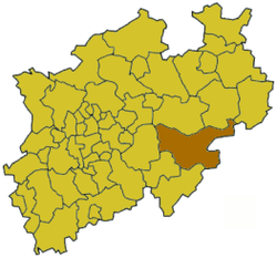
Hochsauerlandkreis (meaning “High Sauerland District” in German) is a Kreis (district) in the east of North Rhine-Westphalia, Germany. Neighboring districts are Soest, Paderborn, Höxter, Waldeck-Frankenberg, Siegen-Wittgenstein, Olpe, Märkischer Kreis.
The district is named “High Sauerland” because two of the highest mountains of the Sauerland mountainous landscape, Langenberg and Kahler Asten are in its territory. With 2,766 ft / 843 m (Langenberg) and 2,762 ft / 842 m (Kahler Asten) these are also the highest mountains of North Rhine-Westphalia.
The district was established in 1975 in the reorganization of the districts in North Rhine-Westphalia by merging the previous districts Arnsberg, Brilon and Meschede.
Geographically the district covers a big part of the Sauerland mountains, including the highest and third highest elevation – the Langenberg near Olsberg with 2,766 ft / 843 m, and the better known Kahler Asten with 2,762 ft / 842 m near Winterberg. These are also the two highest mountains of North Rhine-Westphalia.
Hochsauerland is twinned with the following cities:
Coordinates: 51°15′N 8°20′E / 51.25°N 8.33°E
...
Wikipedia
