Holy Trinity Church of England Primary School, Cuckfield
| Cuckfield | |
|---|---|
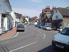
 Cuckfield High Street |
|
|
Cuckfield shown within West Sussex
|
|
| Area | 4.32 km2 (1.67 sq mi) |
| Population | 3,266 2001 Census 3,500 (2011 Census) |
| • Density | 757/km2 (1,960/sq mi) |
| OS grid reference | TQ305245 |
| • London | 34 miles (55 km) N |
| Civil parish |
|
| District | |
| Shire county | |
| Region | |
| Country | England |
| Sovereign state | United Kingdom |
| Post town | Haywards Heath |
| Postcode district | RH17 |
| Dialling code | 01444 |
| Police | Sussex |
| Fire | West Sussex |
| Ambulance | South East Coast |
| EU Parliament | South East England |
| UK Parliament | |
Cuckfield (/ˈkʊkfiːld/ KUUK-feeld) is a large village and civil parish in the Mid Sussex District of West Sussex, England, on the southern slopes of the Weald. It lies 34 miles (55 km) south of London, 13 miles (21 km) north of Brighton, and 31 miles (50 km) east northeast of the county town of Chichester. Nearby towns include Haywards Heath to the southeast and Burgess Hill to the south. It is surrounded on the other sides by the parish of Ansty and Staplefield formerly known as Cuckfield Rural.
Aumale in Normandy has been a twin town since 1993 and Karlstadt in Bavaria since 1998.
Cuckfield is known locally for its idiosyncratic system of mayoral voting; unlimited numbers of votes can be purchased for the price of one penny each, with the winner receiving the most votes.[1] The position is purely honorary and the money raised supports local charities.
Before the modern local government system came into operation in the late 19th century it was described as being in the hundred of Buttinghill, in the rape of Lewes. The civil parish covers an area of 431.58 ha (1066 acres), and had a population of 3,266 persons in the 2001 census, increasing to 3,500 at the 2011 Census.
...
Wikipedia

