Hurricane Omar
| Category 4 major hurricane (SSHWS/NWS) | |

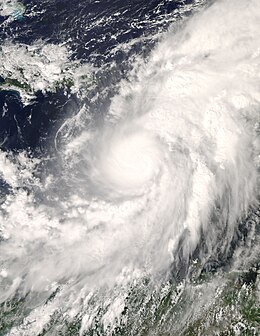
Omar in the Caribbean Sea as a Category 1 hurricane.
|
|
| Formed | October 13, 2008 |
|---|---|
| Dissipated | October 21, 2008 |
| (Extratropical after October 18) | |
| Highest winds |
1-minute sustained: 130 mph (215 km/h) |
| Lowest pressure | 958 mbar (hPa); 28.29 inHg |
| Fatalities | 1 indirect |
| Damage | $79 million (2008 USD) |
| Areas affected | Venezuela, Leeward Antilles, Leeward Islands, Puerto Rico |
| Part of the 2008 Atlantic hurricane season | |
Hurricane Omar was a strong hurricane that took an unusual southwest to northeast track through the eastern Caribbean Sea during October, 2008. Forming out of a tropical disturbance on October 13, Omar initially moved slowly in the eastern Caribbean Sea. By October 15, Omar began to quickly intensify as deep convection developed around the center of circulation. Later that day, an eye developed and the storm began to accelerate to the northeast. Early on October 16, Omar reached its peak intensity with maximum winds of 130 mph (215 km/h) and a barometric pressure of 958 mbar (hPa; 28.29 inHg). Shortly after, the hurricane rapidly weakened to Category 1 intensity. After slightly re-strengthening the next day, Omar weakened to a tropical storm before degenerating into a non-convective low pressure area. The remnants of Omar persisted until October 21 at which time it dissipated to the west of the Azores.
Throughout the eastern Caribbean, Omar affected numerous islands, most of which only recorded minor impacts. Large swells and heavy rains impacted the ABC islands. Antigua and Barbuda sustained $54 million in damages, mainly on Antigua as nine homes were destroyed, several others damaged and many farms were inundated by flood waters. One person died in Puerto Rico after suffering a stress-induced cardiac arrest. The United States Virgin Islands also sustained significant damage, costing roughly $6 million. Numerous boats and homes were damaged and over 100 power poles were snapped. Total losses from the storm were estimated at $79 million.
On September 30, a well-developed tropical wave moved off the eastern coast of Africa and entered the Atlantic Ocean. Deep convection formed around a prominent mid-level circulation as it moved towards the west. However, the convection diminished on October 2 before entering the Caribbean Sea a week later. Upon entering the Caribbean Sea, shower and thunderstorm activity redeveloped around the low. Continued development followed and the low was designated as Tropical Depression Fifteen at 0600 UTC on October 13 while located about 190 miles (305 kilometres) south of the southeastern tip of the Dominican Republic. The previous steady westward motion that the system took across the Atlantic halted as it entered an area of weak steering currents and significant motion was not expected for another day or two. As the structure of the storm improved, it was upgraded to a tropical storm and the National Hurricane Center (NHC) gave it the name Omar.
...
Wikipedia
